You are here: Home > Network List > TA - USArray Transportable Network (new EarthScope stations) Stations List
> Station T27A Campo, CO, USA > Earthquake Result Viewer
T27A Campo, CO, USA - Earthquake Result Viewer
*The percent match for this event was below the threshold and hence no stack was calculated.
| Earthquake location: |
Tonga Islands |
| Earthquake latitude/longitude: |
-17.4/-174.0 |
| Earthquake time(UTC): |
2010/09/04 (247) 08:52:04 GMT |
| Earthquake Depth: |
69 km |
| Earthquake Magnitude: |
5.9 MB, 6.1 MW, 6.0 MW |
| Earthquake Catalog/Contributor: |
WHDF/NEIC |
|
| Network: |
TA USArray Transportable Network (new EarthScope stations) |
| Station: |
T27A Campo, CO, USA |
| Lat/Lon: |
37.06 N/102.72 W |
| Elevation: |
1366 m |
|
| Distance: |
86.1 deg |
| Az: |
49.404 deg |
| Baz: |
245.025 deg |
| Ray Param: |
$rayparam |
*The percent match for this event was below the threshold and hence was not used in the summary stack. |
|
| Radial Match: |
52.936707 % |
| Radial Bump: |
298 |
| Transverse Match: |
55.795223 % |
| Transverse Bump: |
320 |
| SOD ConfigId: |
319893 |
| Insert Time: |
2011-01-13 08:04:05.365 +0000 |
| GWidth: |
2.5 |
| Max Bumps: |
400 |
| Tol: |
0.001 |
|
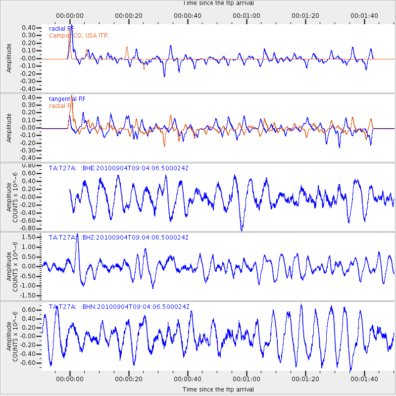
Signal To Noise
| Channel | StoN | STA | LTA |
| TA:T27A: :BHZ:20100904T09:04:06.500024Z | 3.5927112 | 7.5216093E-7 | 2.0935747E-7 |
| TA:T27A: :BHN:20100904T09:04:06.500024Z | 0.57055455 | 2.0872567E-7 | 3.6582946E-7 |
| TA:T27A: :BHE:20100904T09:04:06.500024Z | 1.2383342 | 3.483648E-7 | 2.8131728E-7 |
| Arrivals |
| Ps | |
| PpPs | |
| PsPs/PpSs | |


