You are here: Home > Network List > TA - USArray Transportable Network (new EarthScope stations) Stations List
> Station T26A Comanche National Grassland Park, Kim, CO, USA > Earthquake Result Viewer
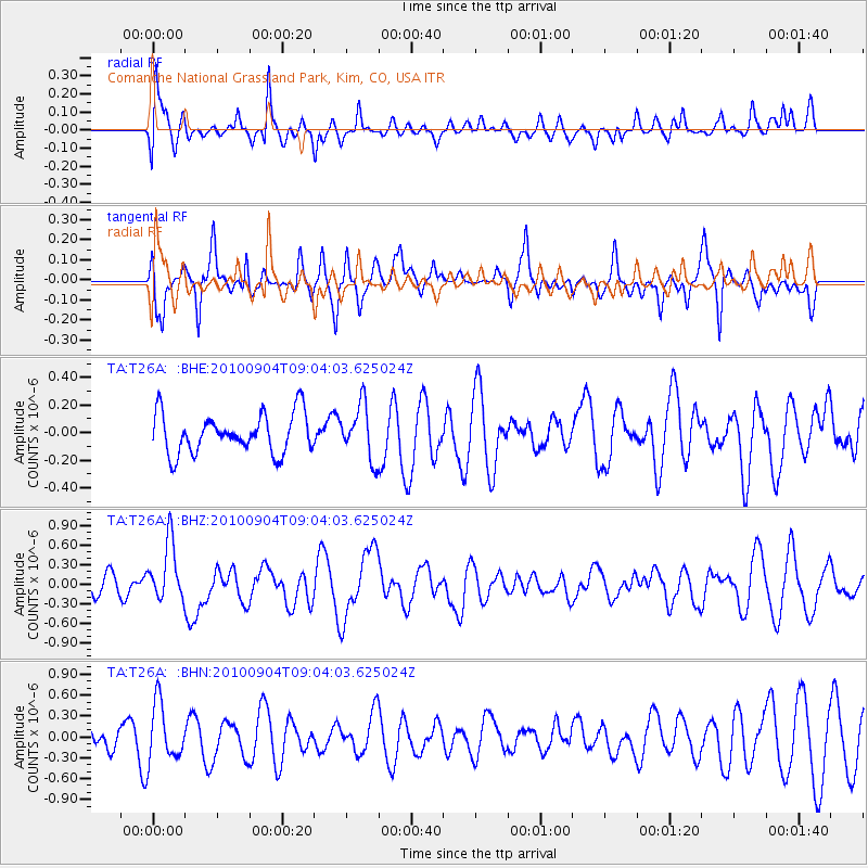
T26A Comanche National Grassland Park, Kim, CO, USA - Earthquake Result Viewer
*The percent match for this event was below the threshold and hence no stack was calculated.
| Earthquake location: |
Tonga Islands |
| Earthquake latitude/longitude: |
-17.4/-174.0 |
| Earthquake time(UTC): |
2010/09/04 (247) 08:52:04 GMT |
| Earthquake Depth: |
69 km |
| Earthquake Magnitude: |
5.9 MB, 6.1 MW, 6.0 MW |
| Earthquake Catalog/Contributor: |
WHDF/NEIC |
|
| Network: |
TA USArray Transportable Network (new EarthScope stations) |
| Station: |
T26A Comanche National Grassland Park, Kim, CO, USA |
| Lat/Lon: |
37.17 N/103.59 W |
| Elevation: |
1830 m |
|
| Distance: |
85.6 deg |
| Az: |
49.003 deg |
| Baz: |
244.472 deg |
| Ray Param: |
$rayparam |
*The percent match for this event was below the threshold and hence was not used in the summary stack. |
|
| Radial Match: |
58.15139 % |
| Radial Bump: |
400 |
| Transverse Match: |
54.70917 % |
| Transverse Bump: |
374 |
| SOD ConfigId: |
319893 |
| Insert Time: |
2011-01-13 08:04:07.926 +0000 |
| GWidth: |
2.5 |
| Max Bumps: |
400 |
| Tol: |
0.001 |
|
Signal To Noise
| Channel | StoN | STA | LTA |
| TA:T26A: :BHZ:20100904T09:04:03.625024Z | 3.0077343 | 4.528201E-7 | 1.505519E-7 |
| TA:T26A: :BHN:20100904T09:04:03.625024Z | 1.7616516 | 4.1115274E-7 | 2.333905E-7 |
| TA:T26A: :BHE:20100904T09:04:03.625024Z | 1.3512553 | 1.9251553E-7 | 1.4247162E-7 |
| Arrivals |
| Ps | |
| PpPs | |
| PsPs/PpSs | |


