You are here: Home > Network List > PS - Pacific21 Stations List
> Station JAY Jayapura, Indonesia > Earthquake Result Viewer
JAY Jayapura, Indonesia - Earthquake Result Viewer
| Earthquake location: |
Fiji Islands Region |
| Earthquake latitude/longitude: |
-21.7/-176.3 |
| Earthquake time(UTC): |
2024/01/18 (018) 04:50:01 GMT |
| Earthquake Depth: |
155 km |
| Earthquake Magnitude: |
5.8 mww |
| Earthquake Catalog/Contributor: |
NEIC PDE/us |
|
| Network: |
PS Pacific21 |
| Station: |
JAY Jayapura, Indonesia |
| Lat/Lon: |
2.51 S/140.70 E |
| Elevation: |
439 m |
|
| Distance: |
46.0 deg |
| Az: |
288.432 deg |
| Baz: |
117.944 deg |
| Ray Param: |
0.07039451 |
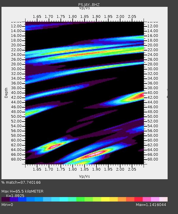
| Estimated Moho Depth: |
65.5 km |
| Estimated Crust Vp/Vs: |
1.89 |
| Assumed Crust Vp: |
6.461 km/s |
| Estimated Crust Vs: |
3.414 km/s |
| Estimated Crust Poisson's Ratio: |
0.31 |
|
| Radial Match: |
87.740166 % |
| Radial Bump: |
400 |
| Transverse Match: |
75.80013 % |
| Transverse Bump: |
400 |
| SOD ConfigId: |
33437571 |
| Insert Time: |
2024-02-01 05:08:12.684 +0000 |
| GWidth: |
2.5 |
| Max Bumps: |
400 |
| Tol: |
0.001 |
|

Signal To Noise
| Channel | StoN | STA | LTA |
| PS:JAY: :BHZ:20240118T04:57:38.061014Z | 18.316833 | 1.2923635E-6 | 7.0556055E-8 |
| PS:JAY: :BHN:20240118T04:57:38.061014Z | 4.6362276 | 6.0282E-7 | 1.3002384E-7 |
| PS:JAY: :BHE:20240118T04:57:38.061014Z | 6.49223 | 6.6577263E-7 | 1.02549144E-7 |
| Arrivals |
| Ps | 9.6 SECOND |
| PpPs | 28 SECOND |
| PsPs/PpSs | 37 SECOND |


