You are here: Home > Network List > TA - USArray Transportable Network (new EarthScope stations) Stations List
> Station P27A Ficken Ranch, Kirk, CO, USA > Earthquake Result Viewer
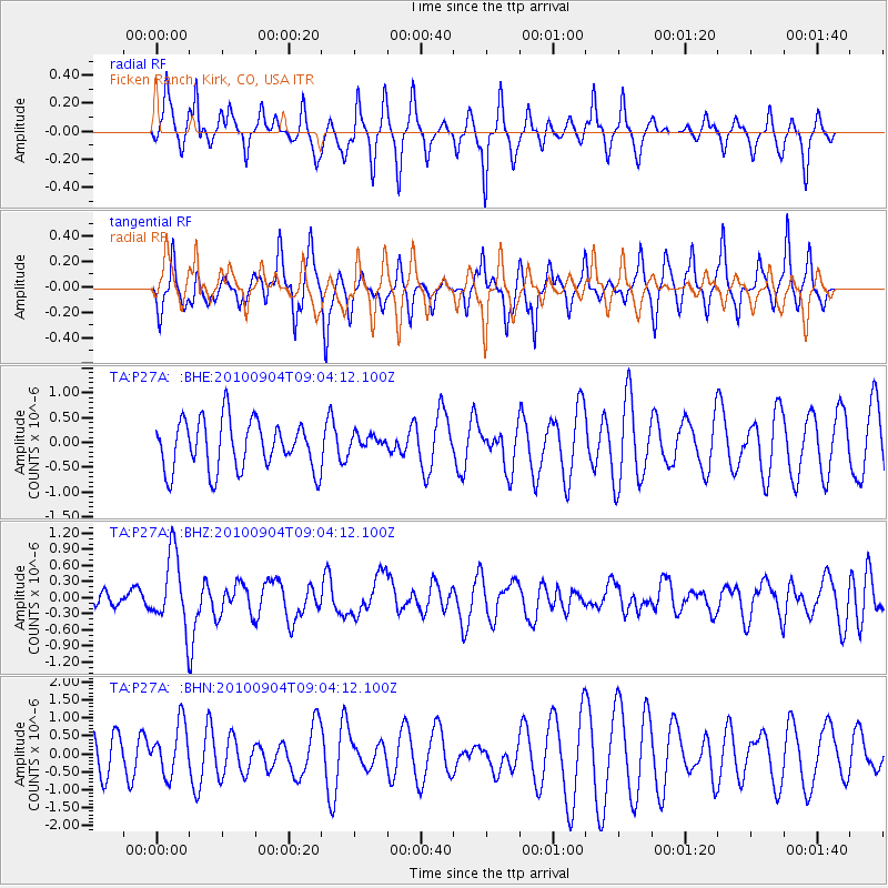
P27A Ficken Ranch, Kirk, CO, USA - Earthquake Result Viewer
*The percent match for this event was below the threshold and hence no stack was calculated.
| Earthquake location: |
Tonga Islands |
| Earthquake latitude/longitude: |
-17.4/-174.0 |
| Earthquake time(UTC): |
2010/09/04 (247) 08:52:04 GMT |
| Earthquake Depth: |
69 km |
| Earthquake Magnitude: |
5.9 MB, 6.1 MW, 6.0 MW |
| Earthquake Catalog/Contributor: |
WHDF/NEIC |
|
| Network: |
TA USArray Transportable Network (new EarthScope stations) |
| Station: |
P27A Ficken Ranch, Kirk, CO, USA |
| Lat/Lon: |
39.56 N/102.58 W |
| Elevation: |
1286 m |
|
| Distance: |
87.3 deg |
| Az: |
47.191 deg |
| Baz: |
244.987 deg |
| Ray Param: |
$rayparam |
*The percent match for this event was below the threshold and hence was not used in the summary stack. |
|
| Radial Match: |
51.889797 % |
| Radial Bump: |
256 |
| Transverse Match: |
63.405716 % |
| Transverse Bump: |
312 |
| SOD ConfigId: |
319893 |
| Insert Time: |
2011-01-13 08:05:00.129 +0000 |
| GWidth: |
2.5 |
| Max Bumps: |
400 |
| Tol: |
0.001 |
|
Signal To Noise
| Channel | StoN | STA | LTA |
| TA:P27A: :BHZ:20100904T09:04:12.100Z | 3.1728027 | 6.7400623E-7 | 2.1243244E-7 |
| TA:P27A: :BHN:20100904T09:04:12.100Z | 1.5783066 | 7.0059815E-7 | 4.4389233E-7 |
| TA:P27A: :BHE:20100904T09:04:12.100Z | 0.33791554 | 1.6864477E-7 | 4.9907374E-7 |
| Arrivals |
| Ps | |
| PpPs | |
| PsPs/PpSs | |


