You are here: Home > Network List > GT - Global Telemetered Seismograph Network (USAF/USGS) Stations List
> Station LPAZ La Paz , Bolivia > Earthquake Result Viewer
LPAZ La Paz , Bolivia - Earthquake Result Viewer

| Earthquake location: |
South Sandwich Islands Region |
| Earthquake latitude/longitude: |
-55.4/-28.6 |
| Earthquake time(UTC): |
2024/01/18 (018) 12:46:14 GMT |
| Earthquake Depth: |
23 km |
| Earthquake Magnitude: |
5.7 mww |
| Earthquake Catalog/Contributor: |
NEIC PDE/us |
|
| Network: |
GT Global Telemetered Seismograph Network (USAF/USGS) |
| Station: |
LPAZ La Paz , Bolivia |
| Lat/Lon: |
16.17 S/68.08 W |
| Elevation: |
4817 m |
|
| Distance: |
49.4 deg |
| Az: |
306.476 deg |
| Baz: |
151.477 deg |
| Ray Param: |
0.06870554 |
| Estimated Moho Depth: |
35.5 km |
| Estimated Crust Vp/Vs: |
1.87 |
| Assumed Crust Vp: |
6.454 km/s |
| Estimated Crust Vs: |
3.456 km/s |
| Estimated Crust Poisson's Ratio: |
0.30 |
|
| Radial Match: |
91.88982 % |
| Radial Bump: |
400 |
| Transverse Match: |
77.43881 % |
| Transverse Bump: |
400 |
| SOD ConfigId: |
33437571 |
| Insert Time: |
2024-02-01 12:52:03.436 +0000 |
| GWidth: |
2.5 |
| Max Bumps: |
400 |
| Tol: |
0.001 |
|
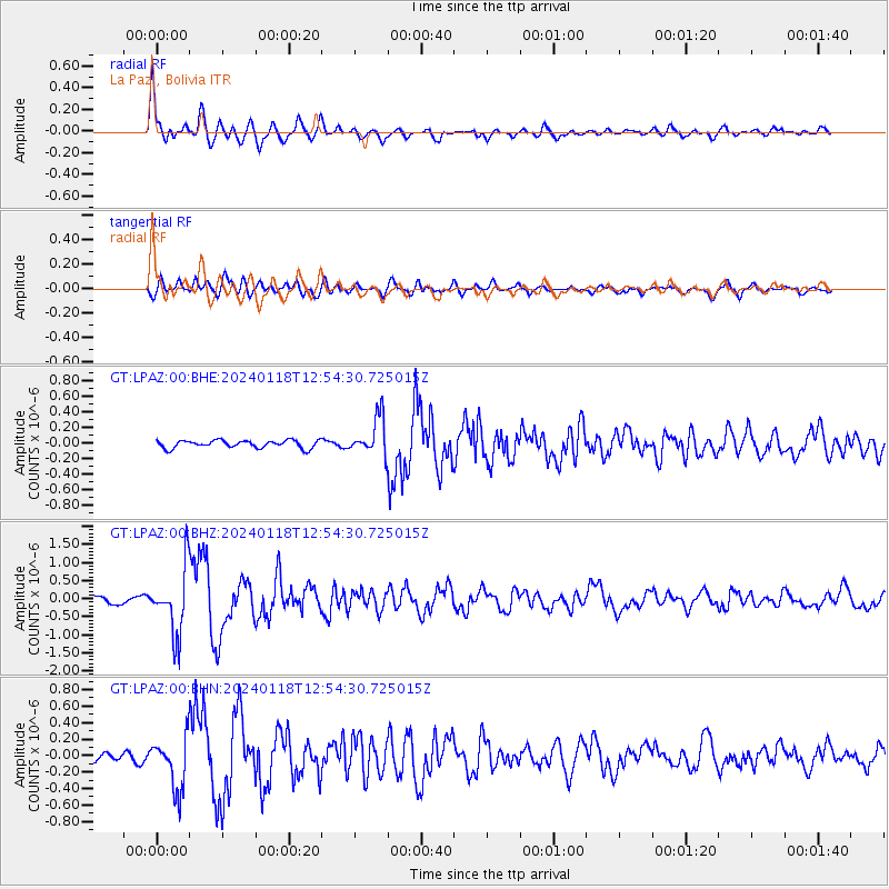
Signal To Noise
| Channel | StoN | STA | LTA |
| GT:LPAZ:00:BHZ:20240118T12:54:30.725015Z | 9.588186 | 8.948322E-7 | 9.332654E-8 |
| GT:LPAZ:00:BHN:20240118T12:54:30.725015Z | 6.1892495 | 3.1737366E-7 | 5.1278214E-8 |
| GT:LPAZ:00:BHE:20240118T12:54:30.725015Z | 6.1903977 | 3.1175915E-7 | 5.036173E-8 |
| Arrivals |
| Ps | 5.0 SECOND |
| PpPs | 15 SECOND |
| PsPs/PpSs | 20 SECOND |


