You are here: Home > Network List > TA - USArray Transportable Network (new EarthScope stations) Stations List
> Station 532A Rocksprings, TX, USA > Earthquake Result Viewer
532A Rocksprings, TX, USA - Earthquake Result Viewer
| Earthquake location: |
Tonga Islands |
| Earthquake latitude/longitude: |
-17.4/-174.0 |
| Earthquake time(UTC): |
2010/09/04 (247) 08:52:04 GMT |
| Earthquake Depth: |
69 km |
| Earthquake Magnitude: |
5.9 MB, 6.1 MW, 6.0 MW |
| Earthquake Catalog/Contributor: |
WHDF/NEIC |
|
| Network: |
TA USArray Transportable Network (new EarthScope stations) |
| Station: |
532A Rocksprings, TX, USA |
| Lat/Lon: |
30.13 N/99.90 W |
| Elevation: |
703 m |
|
| Distance: |
85.5 deg |
| Az: |
56.697 deg |
| Baz: |
247.111 deg |
| Ray Param: |
0.044592034 |
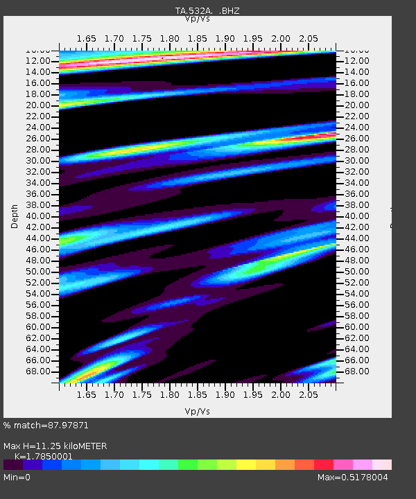
| Estimated Moho Depth: |
11.25 km |
| Estimated Crust Vp/Vs: |
1.79 |
| Assumed Crust Vp: |
6.498 km/s |
| Estimated Crust Vs: |
3.64 km/s |
| Estimated Crust Poisson's Ratio: |
0.27 |
|
| Radial Match: |
87.97871 % |
| Radial Bump: |
377 |
| Transverse Match: |
77.84498 % |
| Transverse Bump: |
343 |
| SOD ConfigId: |
319893 |
| Insert Time: |
2011-01-13 08:05:59.925 +0000 |
| GWidth: |
2.5 |
| Max Bumps: |
400 |
| Tol: |
0.001 |
|
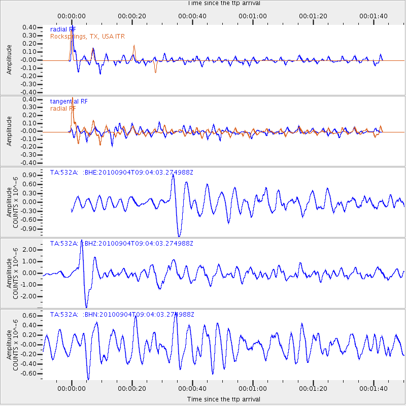
Signal To Noise
| Channel | StoN | STA | LTA |
| TA:532A: :BHZ:20100904T09:04:03.274988Z | 13.0166445 | 1.3589689E-6 | 1.044024E-7 |
| TA:532A: :BHN:20100904T09:04:03.274988Z | 1.1107528 | 1.6007554E-7 | 1.4411447E-7 |
| TA:532A: :BHE:20100904T09:04:03.274988Z | 2.7625253 | 3.9301176E-7 | 1.4226539E-7 |
| Arrivals |
| Ps | 1.4 SECOND |
| PpPs | 4.7 SECOND |
| PsPs/PpSs | 6.1 SECOND |


