You are here: Home > Network List > TA - USArray Transportable Network (new EarthScope stations) Stations List
> Station 530A J-C Ranch, Comstock, TX, USA > Earthquake Result Viewer
530A J-C Ranch, Comstock, TX, USA - Earthquake Result Viewer
| Earthquake location: |
Tonga Islands |
| Earthquake latitude/longitude: |
-17.4/-174.0 |
| Earthquake time(UTC): |
2010/09/04 (247) 08:52:04 GMT |
| Earthquake Depth: |
69 km |
| Earthquake Magnitude: |
5.9 MB, 6.1 MW, 6.0 MW |
| Earthquake Catalog/Contributor: |
WHDF/NEIC |
|
| Network: |
TA USArray Transportable Network (new EarthScope stations) |
| Station: |
530A J-C Ranch, Comstock, TX, USA |
| Lat/Lon: |
30.15 N/101.34 W |
| Elevation: |
636 m |
|
| Distance: |
84.4 deg |
| Az: |
56.185 deg |
| Baz: |
246.35 deg |
| Ray Param: |
0.04540268 |
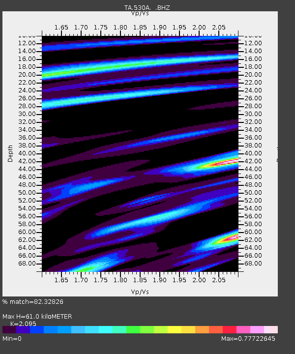
| Estimated Moho Depth: |
61.0 km |
| Estimated Crust Vp/Vs: |
2.10 |
| Assumed Crust Vp: |
6.38 km/s |
| Estimated Crust Vs: |
3.046 km/s |
| Estimated Crust Poisson's Ratio: |
0.35 |
|
| Radial Match: |
82.32826 % |
| Radial Bump: |
400 |
| Transverse Match: |
74.74576 % |
| Transverse Bump: |
400 |
| SOD ConfigId: |
319893 |
| Insert Time: |
2011-01-13 08:06:18.921 +0000 |
| GWidth: |
2.5 |
| Max Bumps: |
400 |
| Tol: |
0.001 |
|
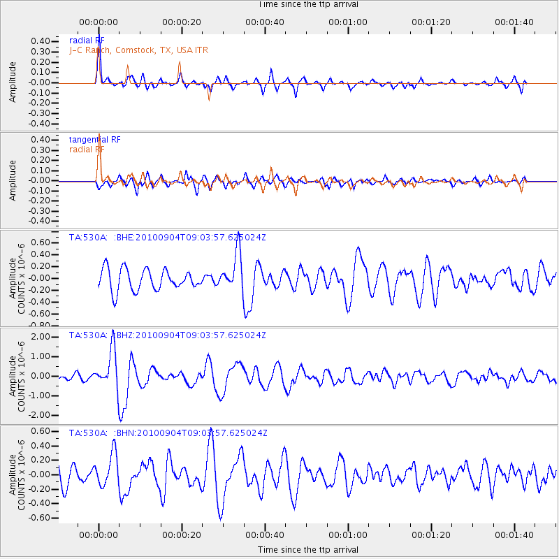
Signal To Noise
| Channel | StoN | STA | LTA |
| TA:530A: :BHZ:20100904T09:03:57.625024Z | 8.322415 | 1.0202995E-6 | 1.2259656E-7 |
| TA:530A: :BHN:20100904T09:03:57.625024Z | 1.6742421 | 2.3338106E-7 | 1.3939504E-7 |
| TA:530A: :BHE:20100904T09:03:57.625024Z | 1.881143 | 3.3416316E-7 | 1.7763837E-7 |
| Arrivals |
| Ps | 11 SECOND |
| PpPs | 29 SECOND |
| PsPs/PpSs | 40 SECOND |


