You are here: Home > Network List > TA - USArray Transportable Network (new EarthScope stations) Stations List
> Station 231A Bronte, TX, USA > Earthquake Result Viewer
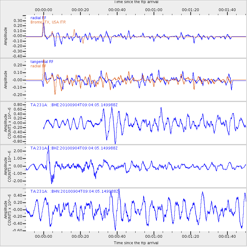
231A Bronte, TX, USA - Earthquake Result Viewer
*The percent match for this event was below the threshold and hence no stack was calculated.
| Earthquake location: |
Tonga Islands |
| Earthquake latitude/longitude: |
-17.4/-174.0 |
| Earthquake time(UTC): |
2010/09/04 (247) 08:52:04 GMT |
| Earthquake Depth: |
69 km |
| Earthquake Magnitude: |
5.9 MB, 6.1 MW, 6.0 MW |
| Earthquake Catalog/Contributor: |
WHDF/NEIC |
|
| Network: |
TA USArray Transportable Network (new EarthScope stations) |
| Station: |
231A Bronte, TX, USA |
| Lat/Lon: |
31.94 N/100.32 W |
| Elevation: |
574 m |
|
| Distance: |
85.9 deg |
| Az: |
54.896 deg |
| Baz: |
246.764 deg |
| Ray Param: |
$rayparam |
*The percent match for this event was below the threshold and hence was not used in the summary stack. |
|
| Radial Match: |
76.47892 % |
| Radial Bump: |
396 |
| Transverse Match: |
65.41746 % |
| Transverse Bump: |
400 |
| SOD ConfigId: |
319893 |
| Insert Time: |
2011-01-13 08:06:23.982 +0000 |
| GWidth: |
2.5 |
| Max Bumps: |
400 |
| Tol: |
0.001 |
|
Signal To Noise
| Channel | StoN | STA | LTA |
| TA:231A: :BHZ:20100904T09:04:05.149988Z | 6.8423705 | 1.1848333E-6 | 1.7316123E-7 |
| TA:231A: :BHN:20100904T09:04:05.149988Z | 2.3814802 | 2.6682136E-7 | 1.12040134E-7 |
| TA:231A: :BHE:20100904T09:04:05.149988Z | 2.4316165 | 3.5032036E-7 | 1.4406892E-7 |
| Arrivals |
| Ps | |
| PpPs | |
| PsPs/PpSs | |


