You are here: Home > Network List > TA - USArray Transportable Network (new EarthScope stations) Stations List
> Station 230A Sterling City, TX, USA > Earthquake Result Viewer
230A Sterling City, TX, USA - Earthquake Result Viewer
| Earthquake location: |
Tonga Islands |
| Earthquake latitude/longitude: |
-17.4/-174.0 |
| Earthquake time(UTC): |
2010/09/04 (247) 08:52:04 GMT |
| Earthquake Depth: |
69 km |
| Earthquake Magnitude: |
5.9 MB, 6.1 MW, 6.0 MW |
| Earthquake Catalog/Contributor: |
WHDF/NEIC |
|
| Network: |
TA USArray Transportable Network (new EarthScope stations) |
| Station: |
230A Sterling City, TX, USA |
| Lat/Lon: |
31.89 N/101.11 W |
| Elevation: |
742 m |
|
| Distance: |
85.2 deg |
| Az: |
54.669 deg |
| Baz: |
246.328 deg |
| Ray Param: |
0.044777136 |
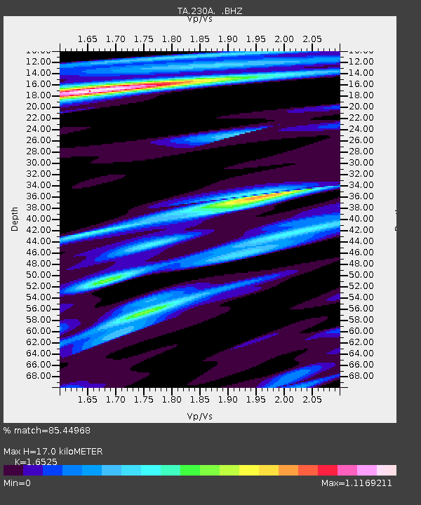
| Estimated Moho Depth: |
17.0 km |
| Estimated Crust Vp/Vs: |
1.65 |
| Assumed Crust Vp: |
6.38 km/s |
| Estimated Crust Vs: |
3.861 km/s |
| Estimated Crust Poisson's Ratio: |
0.21 |
|
| Radial Match: |
85.44968 % |
| Radial Bump: |
368 |
| Transverse Match: |
69.040695 % |
| Transverse Bump: |
358 |
| SOD ConfigId: |
319893 |
| Insert Time: |
2011-01-13 08:06:30.553 +0000 |
| GWidth: |
2.5 |
| Max Bumps: |
400 |
| Tol: |
0.001 |
|
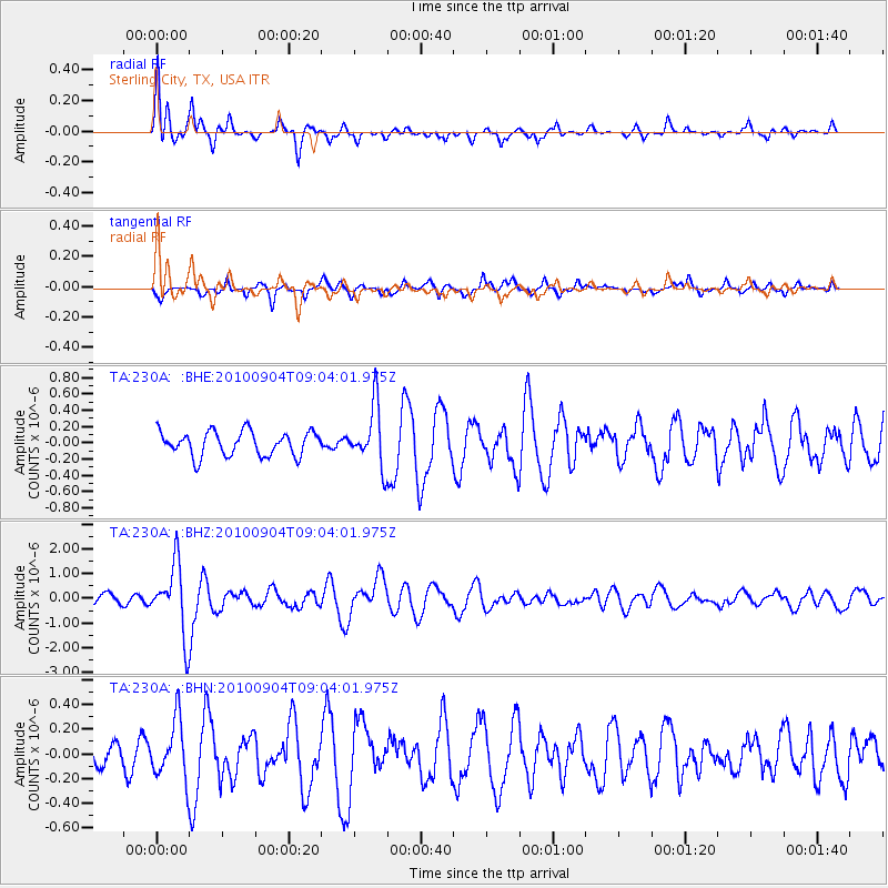
Signal To Noise
| Channel | StoN | STA | LTA |
| TA:230A: :BHZ:20100904T09:04:01.975Z | 8.256073 | 1.4003447E-6 | 1.6961388E-7 |
| TA:230A: :BHN:20100904T09:04:01.975Z | 2.3007798 | 2.3616654E-7 | 1.02646304E-7 |
| TA:230A: :BHE:20100904T09:04:01.975Z | 2.4946082 | 3.6898663E-7 | 1.4791367E-7 |
| Arrivals |
| Ps | 1.8 SECOND |
| PpPs | 6.9 SECOND |
| PsPs/PpSs | 8.7 SECOND |


