You are here: Home > Network List > AK - Alaska Regional Network Stations List
> Station L17K Donlin, AK, USA > Earthquake Result Viewer
L17K Donlin, AK, USA - Earthquake Result Viewer
| Earthquake location: |
Tonga Islands |
| Earthquake latitude/longitude: |
-18.9/-175.1 |
| Earthquake time(UTC): |
2024/01/18 (018) 22:12:20 GMT |
| Earthquake Depth: |
218 km |
| Earthquake Magnitude: |
6.4 Mww |
| Earthquake Catalog/Contributor: |
NEIC PDE/us |
|
| Network: |
AK Alaska Regional Network |
| Station: |
L17K Donlin, AK, USA |
| Lat/Lon: |
62.13 N/158.30 W |
| Elevation: |
338 m |
|
| Distance: |
81.9 deg |
| Az: |
7.907 deg |
| Baz: |
196.09 deg |
| Ray Param: |
0.04673354 |
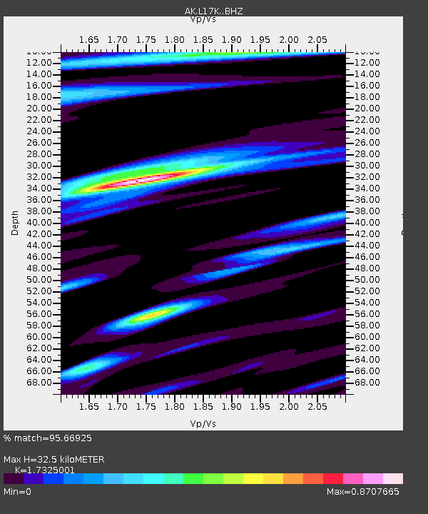
| Estimated Moho Depth: |
32.5 km |
| Estimated Crust Vp/Vs: |
1.73 |
| Assumed Crust Vp: |
6.276 km/s |
| Estimated Crust Vs: |
3.622 km/s |
| Estimated Crust Poisson's Ratio: |
0.25 |
|
| Radial Match: |
95.66925 % |
| Radial Bump: |
264 |
| Transverse Match: |
78.9519 % |
| Transverse Bump: |
400 |
| SOD ConfigId: |
33437571 |
| Insert Time: |
2024-02-01 22:16:14.502 +0000 |
| GWidth: |
2.5 |
| Max Bumps: |
400 |
| Tol: |
0.001 |
|

Signal To Noise
| Channel | StoN | STA | LTA |
| AK:L17K: :BHZ:20240118T22:23:44.720014Z | 0.8654692 | 2.0407232E-7 | 2.3579385E-7 |
| AK:L17K: :BHN:20240118T22:23:44.720014Z | 0.52700496 | 1.4477729E-7 | 2.7471714E-7 |
| AK:L17K: :BHE:20240118T22:23:44.720014Z | 1.7524358 | 6.1757623E-7 | 3.5241018E-7 |
| Arrivals |
| Ps | 3.9 SECOND |
| PpPs | 14 SECOND |
| PsPs/PpSs | 18 SECOND |


