You are here: Home > Network List > AK - Alaska Regional Network Stations List
> Station N15K Kwethluk River, AK, USA > Earthquake Result Viewer
N15K Kwethluk River, AK, USA - Earthquake Result Viewer
| Earthquake location: |
Tonga Islands |
| Earthquake latitude/longitude: |
-18.9/-175.1 |
| Earthquake time(UTC): |
2024/01/18 (018) 22:12:20 GMT |
| Earthquake Depth: |
218 km |
| Earthquake Magnitude: |
6.4 Mww |
| Earthquake Catalog/Contributor: |
NEIC PDE/us |
|
| Network: |
AK Alaska Regional Network |
| Station: |
N15K Kwethluk River, AK, USA |
| Lat/Lon: |
60.17 N/160.09 W |
| Elevation: |
449 m |
|
| Distance: |
79.8 deg |
| Az: |
7.583 deg |
| Baz: |
194.469 deg |
| Ray Param: |
0.04819216 |
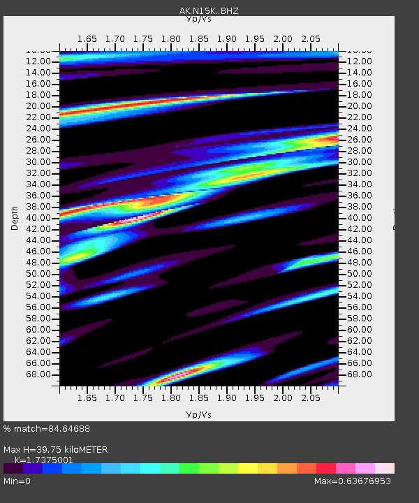
| Estimated Moho Depth: |
39.75 km |
| Estimated Crust Vp/Vs: |
1.74 |
| Assumed Crust Vp: |
6.182 km/s |
| Estimated Crust Vs: |
3.558 km/s |
| Estimated Crust Poisson's Ratio: |
0.25 |
|
| Radial Match: |
84.64688 % |
| Radial Bump: |
400 |
| Transverse Match: |
71.46659 % |
| Transverse Bump: |
400 |
| SOD ConfigId: |
33437571 |
| Insert Time: |
2024-02-01 22:16:35.624 +0000 |
| GWidth: |
2.5 |
| Max Bumps: |
400 |
| Tol: |
0.001 |
|

Signal To Noise
| Channel | StoN | STA | LTA |
| AK:N15K: :BHZ:20240118T22:23:33.480023Z | 4.4052076 | 1.54036E-6 | 3.4966797E-7 |
| AK:N15K: :BHN:20240118T22:23:33.480023Z | 2.706694 | 6.6738187E-7 | 2.4656717E-7 |
| AK:N15K: :BHE:20240118T22:23:33.480023Z | 1.082001 | 3.5736912E-7 | 3.302854E-7 |
| Arrivals |
| Ps | 4.9 SECOND |
| PpPs | 17 SECOND |
| PsPs/PpSs | 22 SECOND |


