You are here: Home > Network List > AU - Australian Seismological Centre Stations List
> Station PSAB2 Pilbara Seismic Array Element B2 > Earthquake Result Viewer
PSAB2 Pilbara Seismic Array Element B2 - Earthquake Result Viewer
| Earthquake location: |
Tonga Islands |
| Earthquake latitude/longitude: |
-18.9/-175.1 |
| Earthquake time(UTC): |
2024/01/18 (018) 22:12:20 GMT |
| Earthquake Depth: |
218 km |
| Earthquake Magnitude: |
6.4 Mww |
| Earthquake Catalog/Contributor: |
NEIC PDE/us |
|
| Network: |
AU Australian Seismological Centre |
| Station: |
PSAB2 Pilbara Seismic Array Element B2 |
| Lat/Lon: |
21.55 S/119.86 E |
| Elevation: |
302 m |
|
| Distance: |
60.6 deg |
| Az: |
255.456 deg |
| Baz: |
100.177 deg |
| Ray Param: |
0.060704242 |
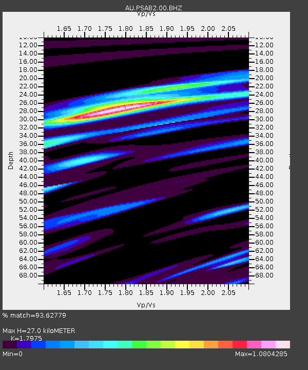
| Estimated Moho Depth: |
27.0 km |
| Estimated Crust Vp/Vs: |
1.80 |
| Assumed Crust Vp: |
6.464 km/s |
| Estimated Crust Vs: |
3.596 km/s |
| Estimated Crust Poisson's Ratio: |
0.28 |
|
| Radial Match: |
93.62779 % |
| Radial Bump: |
400 |
| Transverse Match: |
76.084625 % |
| Transverse Bump: |
400 |
| SOD ConfigId: |
33437571 |
| Insert Time: |
2024-02-01 22:18:43.300 +0000 |
| GWidth: |
2.5 |
| Max Bumps: |
400 |
| Tol: |
0.001 |
|

Signal To Noise
| Channel | StoN | STA | LTA |
| AU:PSAB2:00:BHZ:20240118T22:21:37.994Z | 41.060074 | 1.03449E-5 | 2.519455E-7 |
| AU:PSAB2:00:BH1:20240118T22:21:37.994Z | 20.494677 | 3.0781116E-6 | 1.5019079E-7 |
| AU:PSAB2:00:BH2:20240118T22:21:37.994Z | 23.150347 | 4.159659E-6 | 1.796802E-7 |
| Arrivals |
| Ps | 3.5 SECOND |
| PpPs | 11 SECOND |
| PsPs/PpSs | 15 SECOND |


