You are here: Home > Network List > AU - Australian Seismological Centre Stations List
> Station COOLG Geological Survey of Western Station > Earthquake Result Viewer
COOLG Geological Survey of Western Station - Earthquake Result Viewer
| Earthquake location: |
Tonga Islands |
| Earthquake latitude/longitude: |
-18.9/-175.1 |
| Earthquake time(UTC): |
2024/01/18 (018) 22:12:20 GMT |
| Earthquake Depth: |
218 km |
| Earthquake Magnitude: |
6.4 Mww |
| Earthquake Catalog/Contributor: |
NEIC PDE/us |
|
| Network: |
AU Australian Seismological Centre |
| Station: |
COOLG Geological Survey of Western Station |
| Lat/Lon: |
30.96 S/121.18 E |
| Elevation: |
415 m |
|
| Distance: |
58.3 deg |
| Az: |
244.836 deg |
| Baz: |
94.188 deg |
| Ray Param: |
0.062220126 |
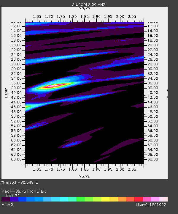
| Estimated Moho Depth: |
36.75 km |
| Estimated Crust Vp/Vs: |
1.72 |
| Assumed Crust Vp: |
6.459 km/s |
| Estimated Crust Vs: |
3.755 km/s |
| Estimated Crust Poisson's Ratio: |
0.24 |
|
| Radial Match: |
80.54941 % |
| Radial Bump: |
400 |
| Transverse Match: |
49.195004 % |
| Transverse Bump: |
400 |
| SOD ConfigId: |
33437571 |
| Insert Time: |
2024-02-01 22:18:58.836 +0000 |
| GWidth: |
2.5 |
| Max Bumps: |
400 |
| Tol: |
0.001 |
|

Signal To Noise
| Channel | StoN | STA | LTA |
| AU:COOLG:00:HHZ:20240118T22:21:21.975019Z | 18.210833 | 6.3804223E-6 | 3.5036413E-7 |
| AU:COOLG:00:HHN:20240118T22:21:21.975019Z | 1.6878927 | 6.855189E-7 | 4.0613892E-7 |
| AU:COOLG:00:HHE:20240118T22:21:21.975019Z | 12.822834 | 3.4772522E-6 | 2.711766E-7 |
| Arrivals |
| Ps | 4.3 SECOND |
| PpPs | 15 SECOND |
| PsPs/PpSs | 19 SECOND |


