You are here: Home > Network List > TA - USArray Transportable Network (new EarthScope stations) Stations List
> Station G27A Dupree, SD, USA > Earthquake Result Viewer
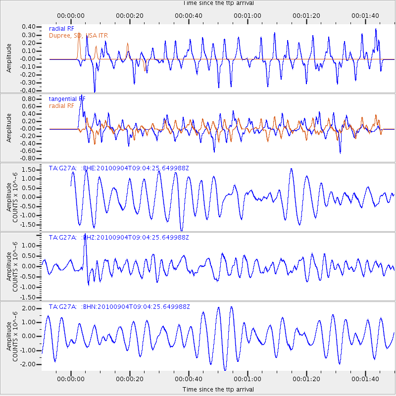
G27A Dupree, SD, USA - Earthquake Result Viewer
*The percent match for this event was below the threshold and hence no stack was calculated.
| Earthquake location: |
Tonga Islands |
| Earthquake latitude/longitude: |
-17.4/-174.0 |
| Earthquake time(UTC): |
2010/09/04 (247) 08:52:04 GMT |
| Earthquake Depth: |
69 km |
| Earthquake Magnitude: |
5.9 MB, 6.1 MW, 6.0 MW |
| Earthquake Catalog/Contributor: |
WHDF/NEIC |
|
| Network: |
TA USArray Transportable Network (new EarthScope stations) |
| Station: |
G27A Dupree, SD, USA |
| Lat/Lon: |
45.38 N/102.93 W |
| Elevation: |
761 m |
|
| Distance: |
89.5 deg |
| Az: |
41.812 deg |
| Baz: |
244.601 deg |
| Ray Param: |
$rayparam |
*The percent match for this event was below the threshold and hence was not used in the summary stack. |
|
| Radial Match: |
35.48461 % |
| Radial Bump: |
233 |
| Transverse Match: |
55.58566 % |
| Transverse Bump: |
285 |
| SOD ConfigId: |
319893 |
| Insert Time: |
2011-01-13 08:10:56.046 +0000 |
| GWidth: |
2.5 |
| Max Bumps: |
400 |
| Tol: |
0.001 |
|
Signal To Noise
| Channel | StoN | STA | LTA |
| TA:G27A: :BHZ:20100904T09:04:25.649988Z | 2.163175 | 4.0551365E-7 | 1.8746225E-7 |
| TA:G27A: :BHN:20100904T09:04:25.649988Z | 0.55792737 | 5.070172E-7 | 9.0875125E-7 |
| TA:G27A: :BHE:20100904T09:04:25.649988Z | 1.0458635 | 8.5042643E-7 | 8.1313334E-7 |
| Arrivals |
| Ps | |
| PpPs | |
| PsPs/PpSs | |


