You are here: Home > Network List > TM - Thai Seismic Monitoring Network Stations List
> Station SKLT Mueang, Songkhla > Earthquake Result Viewer
SKLT Mueang, Songkhla - Earthquake Result Viewer
| Earthquake location: |
Tonga Islands |
| Earthquake latitude/longitude: |
-18.9/-175.1 |
| Earthquake time(UTC): |
2024/01/18 (018) 22:12:20 GMT |
| Earthquake Depth: |
218 km |
| Earthquake Magnitude: |
6.4 Mww |
| Earthquake Catalog/Contributor: |
NEIC PDE/us |
|
| Network: |
TM Thai Seismic Monitoring Network |
| Station: |
SKLT Mueang, Songkhla |
| Lat/Lon: |
7.18 N/100.62 E |
| Elevation: |
11 m |
|
| Distance: |
86.9 deg |
| Az: |
278.616 deg |
| Baz: |
109.404 deg |
| Ray Param: |
0.043213382 |
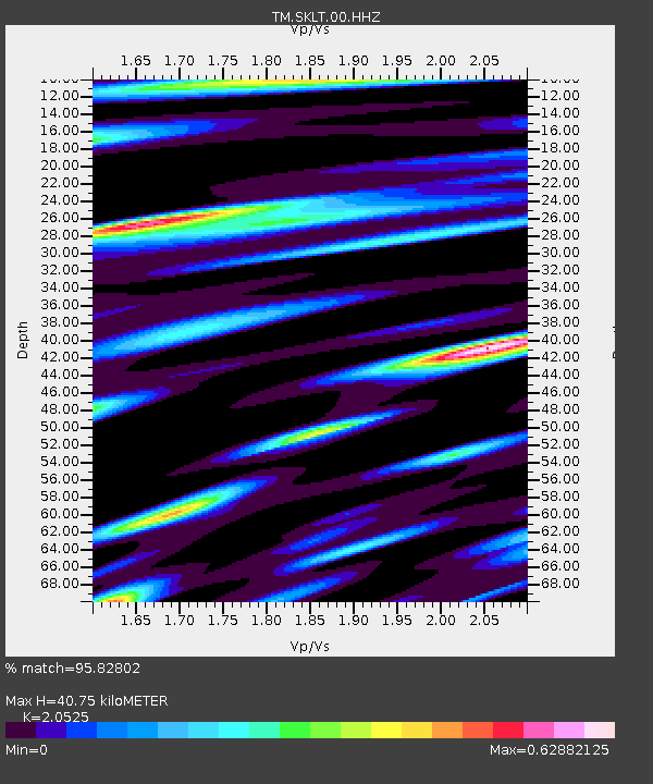
| Estimated Moho Depth: |
40.75 km |
| Estimated Crust Vp/Vs: |
2.05 |
| Assumed Crust Vp: |
6.468 km/s |
| Estimated Crust Vs: |
3.151 km/s |
| Estimated Crust Poisson's Ratio: |
0.34 |
|
| Radial Match: |
95.82802 % |
| Radial Bump: |
400 |
| Transverse Match: |
86.771645 % |
| Transverse Bump: |
400 |
| SOD ConfigId: |
33437571 |
| Insert Time: |
2024-02-01 22:33:47.226 +0000 |
| GWidth: |
2.5 |
| Max Bumps: |
400 |
| Tol: |
0.001 |
|

Signal To Noise
| Channel | StoN | STA | LTA |
| TM:SKLT:00:HHZ:20240118T22:24:09.634992Z | 2.0277784 | 2.3466337E-7 | 1.1572437E-7 |
| TM:SKLT:00:HHN:20240118T22:24:09.634992Z | 0.6421442 | 7.528468E-8 | 1.1723952E-7 |
| TM:SKLT:00:HHE:20240118T22:24:09.634992Z | 1.5970842 | 1.3867789E-7 | 8.683192E-8 |
| Arrivals |
| Ps | 6.8 SECOND |
| PpPs | 19 SECOND |
| PsPs/PpSs | 26 SECOND |


