You are here: Home > Network List > UU - University of Utah Regional Network Stations List
> Station BEID Bear River Idaho > Earthquake Result Viewer
BEID Bear River Idaho - Earthquake Result Viewer
| Earthquake location: |
Tonga Islands |
| Earthquake latitude/longitude: |
-18.9/-175.1 |
| Earthquake time(UTC): |
2024/01/18 (018) 22:12:20 GMT |
| Earthquake Depth: |
218 km |
| Earthquake Magnitude: |
6.4 Mww |
| Earthquake Catalog/Contributor: |
NEIC PDE/us |
|
| Network: |
UU University of Utah Regional Network |
| Station: |
BEID Bear River Idaho |
| Lat/Lon: |
42.12 N/111.78 W |
| Elevation: |
1864 m |
|
| Distance: |
84.2 deg |
| Az: |
41.946 deg |
| Baz: |
238.258 deg |
| Ray Param: |
0.045093514 |
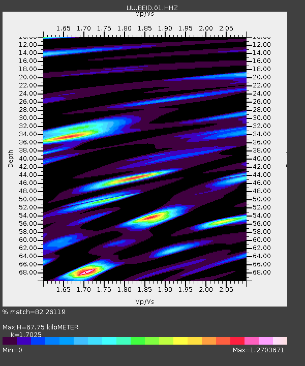
| Estimated Moho Depth: |
67.75 km |
| Estimated Crust Vp/Vs: |
1.70 |
| Assumed Crust Vp: |
6.207 km/s |
| Estimated Crust Vs: |
3.646 km/s |
| Estimated Crust Poisson's Ratio: |
0.24 |
|
| Radial Match: |
82.26119 % |
| Radial Bump: |
400 |
| Transverse Match: |
78.02795 % |
| Transverse Bump: |
400 |
| SOD ConfigId: |
33437571 |
| Insert Time: |
2024-02-01 22:36:23.024 +0000 |
| GWidth: |
2.5 |
| Max Bumps: |
400 |
| Tol: |
0.001 |
|

Signal To Noise
| Channel | StoN | STA | LTA |
| UU:BEID:01:HHZ:20240118T22:23:56.679975Z | 1.2932115 | 4.0583816E-7 | 3.1382197E-7 |
| UU:BEID:01:HHN:20240118T22:23:56.679975Z | 0.6299988 | 1.9080285E-7 | 3.0286225E-7 |
| UU:BEID:01:HHE:20240118T22:23:56.679975Z | 1.5216397 | 4.8919424E-7 | 3.214915E-7 |
| Arrivals |
| Ps | 7.9 SECOND |
| PpPs | 29 SECOND |
| PsPs/PpSs | 37 SECOND |


