You are here: Home > Network List > CI - Caltech Regional Seismic Network Stations List
> Station SWS Sam W. Stewart, Westmorland, CA, USA > Earthquake Result Viewer
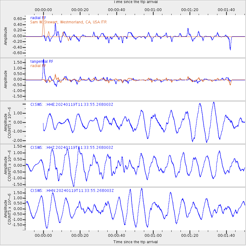
SWS Sam W. Stewart, Westmorland, CA, USA - Earthquake Result Viewer
*The percent match for this event was below the threshold and hence no stack was calculated.
| Earthquake location: |
Colombia |
| Earthquake latitude/longitude: |
4.7/-75.9 |
| Earthquake time(UTC): |
2024/01/19 (019) 11:26:03 GMT |
| Earthquake Depth: |
61 km |
| Earthquake Magnitude: |
5.6 mww |
| Earthquake Catalog/Contributor: |
NEIC PDE/us |
|
| Network: |
CI Caltech Regional Seismic Network |
| Station: |
SWS Sam W. Stewart, Westmorland, CA, USA |
| Lat/Lon: |
32.94 N/115.80 W |
| Elevation: |
140 m |
|
| Distance: |
46.6 deg |
| Az: |
312.045 deg |
| Baz: |
118.336 deg |
| Ray Param: |
$rayparam |
*The percent match for this event was below the threshold and hence was not used in the summary stack. |
|
| Radial Match: |
75.55776 % |
| Radial Bump: |
400 |
| Transverse Match: |
71.44881 % |
| Transverse Bump: |
400 |
| SOD ConfigId: |
33437571 |
| Insert Time: |
2024-02-02 11:34:17.402 +0000 |
| GWidth: |
2.5 |
| Max Bumps: |
400 |
| Tol: |
0.001 |
|
Signal To Noise
| Channel | StoN | STA | LTA |
| CI:SWS: :HHZ:20240119T11:33:55.268003Z | 1.5798713 | 7.185166E-7 | 4.5479442E-7 |
| CI:SWS: :HHN:20240119T11:33:55.268003Z | 2.6931076 | 1.0992953E-6 | 4.081884E-7 |
| CI:SWS: :HHE:20240119T11:33:55.268003Z | 1.0914216 | 5.9042054E-7 | 5.409647E-7 |
| Arrivals |
| Ps | |
| PpPs | |
| PsPs/PpSs | |


