You are here: Home > Network List > TA - USArray Transportable Network (new EarthScope stations) Stations List
> Station V34A Guthrie, OK, USA > Earthquake Result Viewer
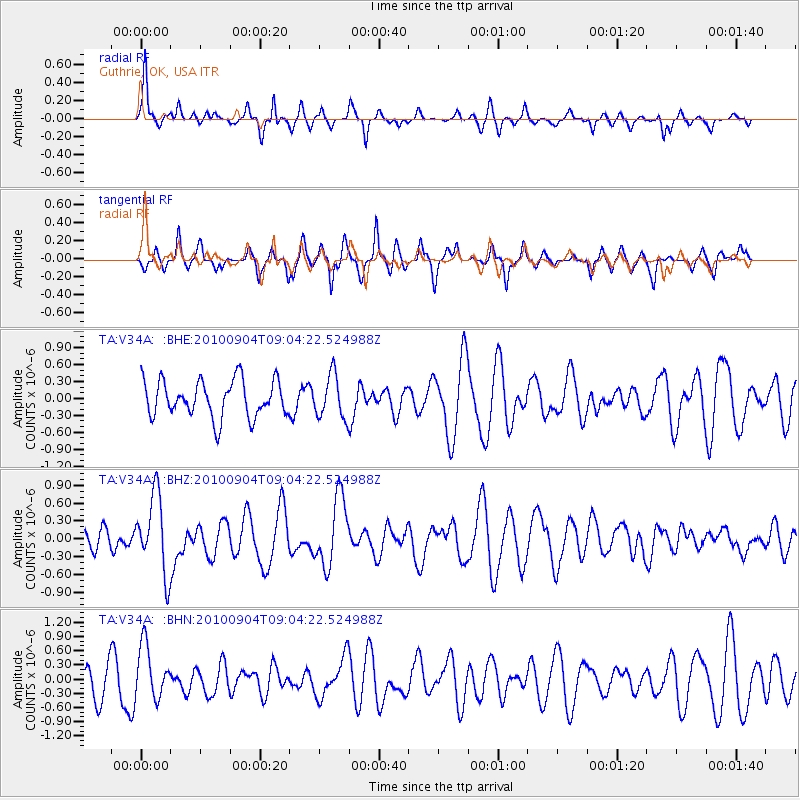
V34A Guthrie, OK, USA - Earthquake Result Viewer
*The percent match for this event was below the threshold and hence no stack was calculated.
| Earthquake location: |
Tonga Islands |
| Earthquake latitude/longitude: |
-17.4/-174.0 |
| Earthquake time(UTC): |
2010/09/04 (247) 08:52:04 GMT |
| Earthquake Depth: |
69 km |
| Earthquake Magnitude: |
5.9 MB, 6.1 MW, 6.0 MW |
| Earthquake Catalog/Contributor: |
WHDF/NEIC |
|
| Network: |
TA USArray Transportable Network (new EarthScope stations) |
| Station: |
V34A Guthrie, OK, USA |
| Lat/Lon: |
35.83 N/97.52 W |
| Elevation: |
329 m |
|
| Distance: |
89.5 deg |
| Az: |
52.194 deg |
| Baz: |
248.21 deg |
| Ray Param: |
$rayparam |
*The percent match for this event was below the threshold and hence was not used in the summary stack. |
|
| Radial Match: |
68.2692 % |
| Radial Bump: |
287 |
| Transverse Match: |
52.351215 % |
| Transverse Bump: |
242 |
| SOD ConfigId: |
319893 |
| Insert Time: |
2011-01-13 08:15:22.098 +0000 |
| GWidth: |
2.5 |
| Max Bumps: |
400 |
| Tol: |
0.001 |
|
Signal To Noise
| Channel | StoN | STA | LTA |
| TA:V34A: :BHZ:20100904T09:04:22.524988Z | 2.7327757 | 6.543879E-7 | 2.3945907E-7 |
| TA:V34A: :BHN:20100904T09:04:22.524988Z | 1.3335845 | 5.590712E-7 | 4.1922445E-7 |
| TA:V34A: :BHE:20100904T09:04:22.524988Z | 1.1968133 | 3.8715248E-7 | 3.234861E-7 |
| Arrivals |
| Ps | |
| PpPs | |
| PsPs/PpSs | |


