You are here: Home > Network List > TA - USArray Transportable Network (new EarthScope stations) Stations List
> Station 533A Kerrville, TX, USA > Earthquake Result Viewer
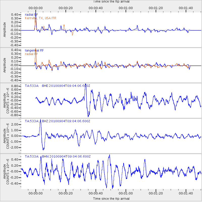
533A Kerrville, TX, USA - Earthquake Result Viewer

| Earthquake location: |
Tonga Islands |
| Earthquake latitude/longitude: |
-17.4/-174.0 |
| Earthquake time(UTC): |
2010/09/04 (247) 08:52:04 GMT |
| Earthquake Depth: |
69 km |
| Earthquake Magnitude: |
5.9 MB, 6.1 MW, 6.0 MW |
| Earthquake Catalog/Contributor: |
WHDF/NEIC |
|
| Network: |
TA USArray Transportable Network (new EarthScope stations) |
| Station: |
533A Kerrville, TX, USA |
| Lat/Lon: |
30.07 N/99.04 W |
| Elevation: |
556 m |
|
| Distance: |
86.2 deg |
| Az: |
57.04 deg |
| Baz: |
247.57 deg |
| Ray Param: |
0.044114392 |
| Estimated Moho Depth: |
23.0 km |
| Estimated Crust Vp/Vs: |
1.60 |
| Assumed Crust Vp: |
6.498 km/s |
| Estimated Crust Vs: |
4.061 km/s |
| Estimated Crust Poisson's Ratio: |
0.18 |
|
| Radial Match: |
86.792946 % |
| Radial Bump: |
327 |
| Transverse Match: |
77.597374 % |
| Transverse Bump: |
400 |
| SOD ConfigId: |
319893 |
| Insert Time: |
2011-01-13 08:15:58.069 +0000 |
| GWidth: |
2.5 |
| Max Bumps: |
400 |
| Tol: |
0.001 |
|
Signal To Noise
| Channel | StoN | STA | LTA |
| TA:533A: :BHZ:20100904T09:04:06.600Z | 14.812805 | 1.2255956E-6 | 8.273893E-8 |
| TA:533A: :BHN:20100904T09:04:06.600Z | 1.7241235 | 2.0247249E-7 | 1.1743503E-7 |
| TA:533A: :BHE:20100904T09:04:06.600Z | 4.062499 | 4.3089756E-7 | 1.0606712E-7 |
| Arrivals |
| Ps | 2.2 SECOND |
| PpPs | 9.0 SECOND |
| PsPs/PpSs | 11 SECOND |


