You are here: Home > Network List > TA - USArray Transportable Network (new EarthScope stations) Stations List
> Station 434A Burnet, TX, USA > Earthquake Result Viewer
434A Burnet, TX, USA - Earthquake Result Viewer
| Earthquake location: |
Tonga Islands |
| Earthquake latitude/longitude: |
-17.4/-174.0 |
| Earthquake time(UTC): |
2010/09/04 (247) 08:52:04 GMT |
| Earthquake Depth: |
69 km |
| Earthquake Magnitude: |
5.9 MB, 6.1 MW, 6.0 MW |
| Earthquake Catalog/Contributor: |
WHDF/NEIC |
|
| Network: |
TA USArray Transportable Network (new EarthScope stations) |
| Station: |
434A Burnet, TX, USA |
| Lat/Lon: |
30.81 N/98.27 W |
| Elevation: |
462 m |
|
| Distance: |
87.1 deg |
| Az: |
56.605 deg |
| Baz: |
247.931 deg |
| Ray Param: |
0.04346566 |
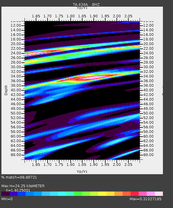
| Estimated Moho Depth: |
24.25 km |
| Estimated Crust Vp/Vs: |
1.61 |
| Assumed Crust Vp: |
6.498 km/s |
| Estimated Crust Vs: |
4.029 km/s |
| Estimated Crust Poisson's Ratio: |
0.19 |
|
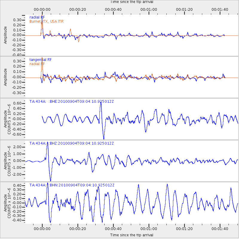
| Radial Match: |
86.69721 % |
| Radial Bump: |
365 |
| Transverse Match: |
64.89674 % |
| Transverse Bump: |
388 |
| SOD ConfigId: |
319893 |
| Insert Time: |
2011-01-13 08:16:10.987 +0000 |
| GWidth: |
2.5 |
| Max Bumps: |
400 |
| Tol: |
0.001 |
|
Signal To Noise
| Channel | StoN | STA | LTA |
| TA:434A: :BHZ:20100904T09:04:10.925012Z | 15.450216 | 1.3831809E-6 | 8.9525024E-8 |
| TA:434A: :BHN:20100904T09:04:10.925012Z | 1.7897034 | 2.3520106E-7 | 1.3141903E-7 |
| TA:434A: :BHE:20100904T09:04:10.925012Z | 3.2595408 | 3.5295938E-7 | 1.08285E-7 |
| Arrivals |
| Ps | 2.3 SECOND |
| PpPs | 9.5 SECOND |
| PsPs/PpSs | 12 SECOND |


