You are here: Home > Network List > TA - USArray Transportable Network (new EarthScope stations) Stations List
> Station 234A Clairette, TX, USA > Earthquake Result Viewer
234A Clairette, TX, USA - Earthquake Result Viewer

| Earthquake location: |
Tonga Islands |
| Earthquake latitude/longitude: |
-17.4/-174.0 |
| Earthquake time(UTC): |
2010/09/04 (247) 08:52:04 GMT |
| Earthquake Depth: |
69 km |
| Earthquake Magnitude: |
5.9 MB, 6.1 MW, 6.0 MW |
| Earthquake Catalog/Contributor: |
WHDF/NEIC |
|
| Network: |
TA USArray Transportable Network (new EarthScope stations) |
| Station: |
234A Clairette, TX, USA |
| Lat/Lon: |
32.00 N/98.14 W |
| Elevation: |
358 m |
|
| Distance: |
87.6 deg |
| Az: |
55.547 deg |
| Baz: |
247.95 deg |
| Ray Param: |
0.043069743 |
| Estimated Moho Depth: |
37.25 km |
| Estimated Crust Vp/Vs: |
1.79 |
| Assumed Crust Vp: |
6.426 km/s |
| Estimated Crust Vs: |
3.585 km/s |
| Estimated Crust Poisson's Ratio: |
0.27 |
|
| Radial Match: |
80.147995 % |
| Radial Bump: |
339 |
| Transverse Match: |
66.673615 % |
| Transverse Bump: |
373 |
| SOD ConfigId: |
319893 |
| Insert Time: |
2011-01-13 08:17:09.466 +0000 |
| GWidth: |
2.5 |
| Max Bumps: |
400 |
| Tol: |
0.001 |
|
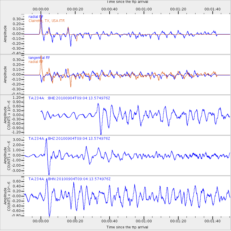
Signal To Noise
| Channel | StoN | STA | LTA |
| TA:234A: :BHZ:20100904T09:04:13.574976Z | 13.05591 | 1.6497042E-6 | 1.263569E-7 |
| TA:234A: :BHN:20100904T09:04:13.574976Z | 2.9806702 | 3.2717114E-7 | 1.0976429E-7 |
| TA:234A: :BHE:20100904T09:04:13.574976Z | 3.1334991 | 4.1804273E-7 | 1.3341082E-7 |
| Arrivals |
| Ps | 4.7 SECOND |
| PpPs | 16 SECOND |
| PsPs/PpSs | 21 SECOND |


