You are here: Home > Network List > AU - Australian Seismological Centre Stations List
> Station KMBL Kambalda, WA > Earthquake Result Viewer
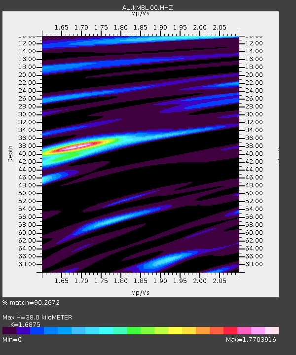
KMBL Kambalda, WA - Earthquake Result Viewer
| Earthquake location: |
Mariana Islands |
| Earthquake latitude/longitude: |
18.5/145.6 |
| Earthquake time(UTC): |
2024/01/20 (020) 15:48:41 GMT |
| Earthquake Depth: |
195 km |
| Earthquake Magnitude: |
6.1 mww |
| Earthquake Catalog/Contributor: |
NEIC PDE/us |
|
| Network: |
AU Australian Seismological Centre |
| Station: |
KMBL Kambalda, WA |
| Lat/Lon: |
31.37 S/121.88 E |
| Elevation: |
370 m |
|
| Distance: |
54.5 deg |
| Az: |
204.961 deg |
| Baz: |
27.919 deg |
| Ray Param: |
0.06471334 |
| Estimated Moho Depth: |
38.0 km |
| Estimated Crust Vp/Vs: |
1.69 |
| Assumed Crust Vp: |
6.459 km/s |
| Estimated Crust Vs: |
3.828 km/s |
| Estimated Crust Poisson's Ratio: |
0.23 |
|
| Radial Match: |
90.2672 % |
| Radial Bump: |
286 |
| Transverse Match: |
70.9143 % |
| Transverse Bump: |
400 |
| SOD ConfigId: |
33437571 |
| Insert Time: |
2024-02-03 15:55:43.455 +0000 |
| GWidth: |
2.5 |
| Max Bumps: |
400 |
| Tol: |
0.001 |
|

Signal To Noise
| Channel | StoN | STA | LTA |
| AU:KMBL:00:HHZ:20240120T15:57:18.48502Z | 21.73885 | 1.8594491E-6 | 8.553576E-8 |
| AU:KMBL:00:HHN:20240120T15:57:18.48502Z | 11.442016 | 8.1360577E-7 | 7.1106854E-8 |
| AU:KMBL:00:HHE:20240120T15:57:18.48502Z | 6.0746317 | 4.809913E-7 | 7.918032E-8 |
| Arrivals |
| Ps | 4.3 SECOND |
| PpPs | 15 SECOND |
| PsPs/PpSs | 19 SECOND |


