You are here: Home > Network List > CI - Caltech Regional Seismic Network Stations List
> Station MUR Murrieta > Earthquake Result Viewer
MUR Murrieta - Earthquake Result Viewer
*The percent match for this event was below the threshold and hence no stack was calculated.
| Earthquake location: |
Mariana Islands |
| Earthquake latitude/longitude: |
18.5/145.6 |
| Earthquake time(UTC): |
2024/01/20 (020) 15:48:41 GMT |
| Earthquake Depth: |
195 km |
| Earthquake Magnitude: |
6.1 mww |
| Earthquake Catalog/Contributor: |
NEIC PDE/us |
|
| Network: |
CI Caltech Regional Seismic Network |
| Station: |
MUR Murrieta |
| Lat/Lon: |
33.60 N/117.20 W |
| Elevation: |
562 m |
|
| Distance: |
85.8 deg |
| Az: |
56.124 deg |
| Baz: |
289.246 deg |
| Ray Param: |
$rayparam |
*The percent match for this event was below the threshold and hence was not used in the summary stack. |
|
| Radial Match: |
71.10215 % |
| Radial Bump: |
314 |
| Transverse Match: |
68.953026 % |
| Transverse Bump: |
400 |
| SOD ConfigId: |
33437571 |
| Insert Time: |
2024-02-03 16:02:25.517 +0000 |
| GWidth: |
2.5 |
| Max Bumps: |
400 |
| Tol: |
0.001 |
|
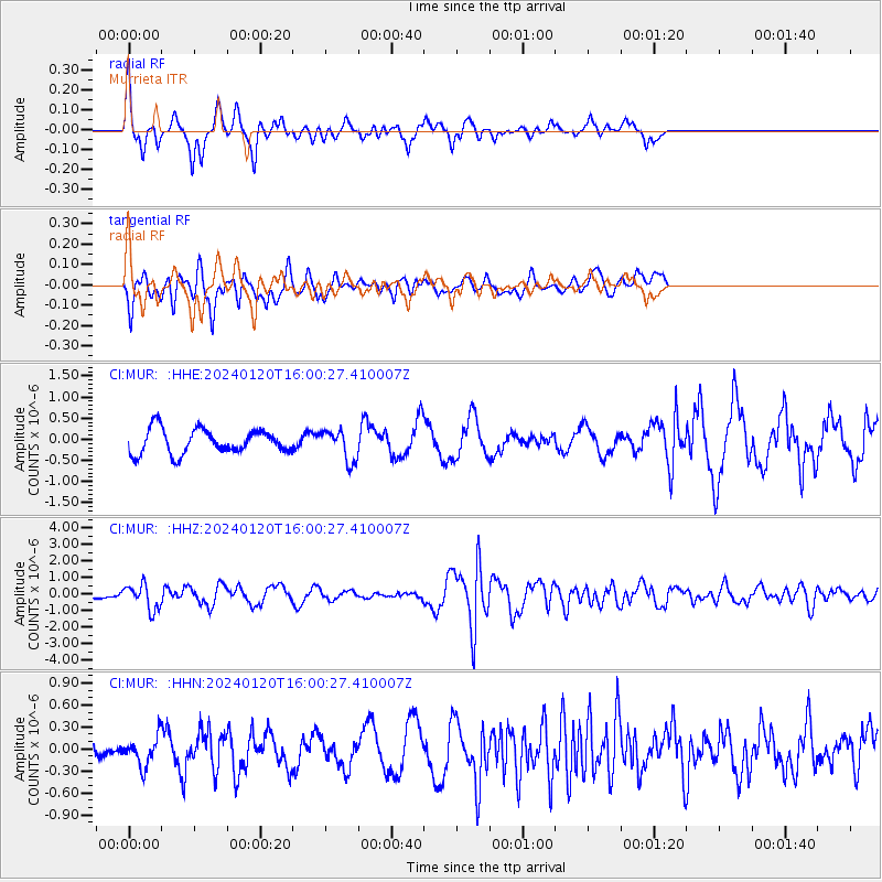
Signal To Noise
| Channel | StoN | STA | LTA |
| CI:MUR: :HHZ:20240120T16:00:27.410007Z | 3.562573 | 7.553659E-7 | 2.1202818E-7 |
| CI:MUR: :HHN:20240120T16:00:27.410007Z | 1.2207919 | 1.9990863E-7 | 1.6375323E-7 |
| CI:MUR: :HHE:20240120T16:00:27.410007Z | 1.273803 | 3.6766696E-7 | 2.886372E-7 |
| Arrivals |
| Ps | |
| PpPs | |
| PsPs/PpSs | |


