You are here: Home > Network List > TA - USArray Transportable Network (new EarthScope stations) Stations List
> Station L04D Klamath Falls, OR, USA > Earthquake Result Viewer
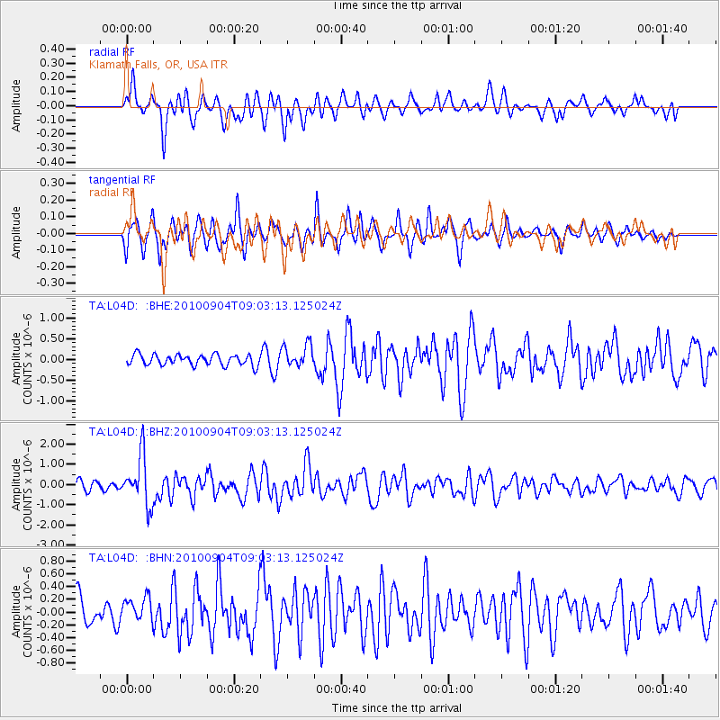
L04D Klamath Falls, OR, USA - Earthquake Result Viewer
*The percent match for this event was below the threshold and hence no stack was calculated.
| Earthquake location: |
Tonga Islands |
| Earthquake latitude/longitude: |
-17.4/-174.0 |
| Earthquake time(UTC): |
2010/09/04 (247) 08:52:04 GMT |
| Earthquake Depth: |
69 km |
| Earthquake Magnitude: |
5.9 MB, 6.1 MW, 6.0 MW |
| Earthquake Catalog/Contributor: |
WHDF/NEIC |
|
| Network: |
TA USArray Transportable Network (new EarthScope stations) |
| Station: |
L04D Klamath Falls, OR, USA |
| Lat/Lon: |
42.22 N/122.30 W |
| Elevation: |
1437 m |
|
| Distance: |
76.0 deg |
| Az: |
36.915 deg |
| Baz: |
230.548 deg |
| Ray Param: |
$rayparam |
*The percent match for this event was below the threshold and hence was not used in the summary stack. |
|
| Radial Match: |
69.47695 % |
| Radial Bump: |
400 |
| Transverse Match: |
76.606094 % |
| Transverse Bump: |
400 |
| SOD ConfigId: |
319893 |
| Insert Time: |
2011-01-13 08:24:52.930 +0000 |
| GWidth: |
2.5 |
| Max Bumps: |
400 |
| Tol: |
0.001 |
|
Signal To Noise
| Channel | StoN | STA | LTA |
| TA:L04D: :BHZ:20100904T09:03:13.125024Z | 6.966402 | 1.2252797E-6 | 1.7588415E-7 |
| TA:L04D: :BHN:20100904T09:03:13.125024Z | 0.71000224 | 1.9239995E-7 | 2.70985E-7 |
| TA:L04D: :BHE:20100904T09:03:13.125024Z | 2.192089 | 2.818093E-7 | 1.285574E-7 |
| Arrivals |
| Ps | |
| PpPs | |
| PsPs/PpSs | |


