You are here: Home > Network List > TA - USArray Transportable Network (new EarthScope stations) Stations List
> Station J01D Myrtle Point, OR, USA > Earthquake Result Viewer
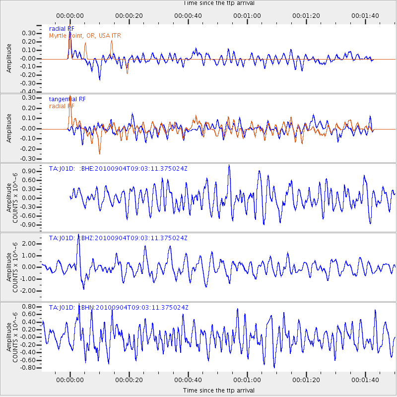
J01D Myrtle Point, OR, USA - Earthquake Result Viewer
*The percent match for this event was below the threshold and hence no stack was calculated.
| Earthquake location: |
Tonga Islands |
| Earthquake latitude/longitude: |
-17.4/-174.0 |
| Earthquake time(UTC): |
2010/09/04 (247) 08:52:04 GMT |
| Earthquake Depth: |
69 km |
| Earthquake Magnitude: |
5.9 MB, 6.1 MW, 6.0 MW |
| Earthquake Catalog/Contributor: |
WHDF/NEIC |
|
| Network: |
TA USArray Transportable Network (new EarthScope stations) |
| Station: |
J01D Myrtle Point, OR, USA |
| Lat/Lon: |
43.16 N/123.93 W |
| Elevation: |
131 m |
|
| Distance: |
75.7 deg |
| Az: |
35.374 deg |
| Baz: |
229.074 deg |
| Ray Param: |
$rayparam |
*The percent match for this event was below the threshold and hence was not used in the summary stack. |
|
| Radial Match: |
54.106785 % |
| Radial Bump: |
400 |
| Transverse Match: |
44.88097 % |
| Transverse Bump: |
400 |
| SOD ConfigId: |
319893 |
| Insert Time: |
2011-01-13 08:25:18.581 +0000 |
| GWidth: |
2.5 |
| Max Bumps: |
400 |
| Tol: |
0.001 |
|
Signal To Noise
| Channel | StoN | STA | LTA |
| TA:J01D: :BHZ:20100904T09:03:11.375024Z | 3.6840112 | 1.1484299E-6 | 3.1173352E-7 |
| TA:J01D: :BHN:20100904T09:03:11.375024Z | 1.3908622 | 4.07419E-7 | 2.929255E-7 |
| TA:J01D: :BHE:20100904T09:03:11.375024Z | 1.4489503 | 3.467032E-7 | 2.3927888E-7 |
| Arrivals |
| Ps | |
| PpPs | |
| PsPs/PpSs | |


