You are here: Home > Network List > MB - Montana Regional Seismic Network Stations List
> Station FCMT Ford Creek > Earthquake Result Viewer
FCMT Ford Creek - Earthquake Result Viewer
| Earthquake location: |
Mariana Islands |
| Earthquake latitude/longitude: |
18.5/145.6 |
| Earthquake time(UTC): |
2024/01/20 (020) 15:48:41 GMT |
| Earthquake Depth: |
195 km |
| Earthquake Magnitude: |
6.1 mww |
| Earthquake Catalog/Contributor: |
NEIC PDE/us |
|
| Network: |
MB Montana Regional Seismic Network |
| Station: |
FCMT Ford Creek |
| Lat/Lon: |
46.46 N/110.86 W |
| Elevation: |
1836 m |
|
| Distance: |
85.8 deg |
| Az: |
42.361 deg |
| Baz: |
292.316 deg |
| Ray Param: |
0.044073023 |
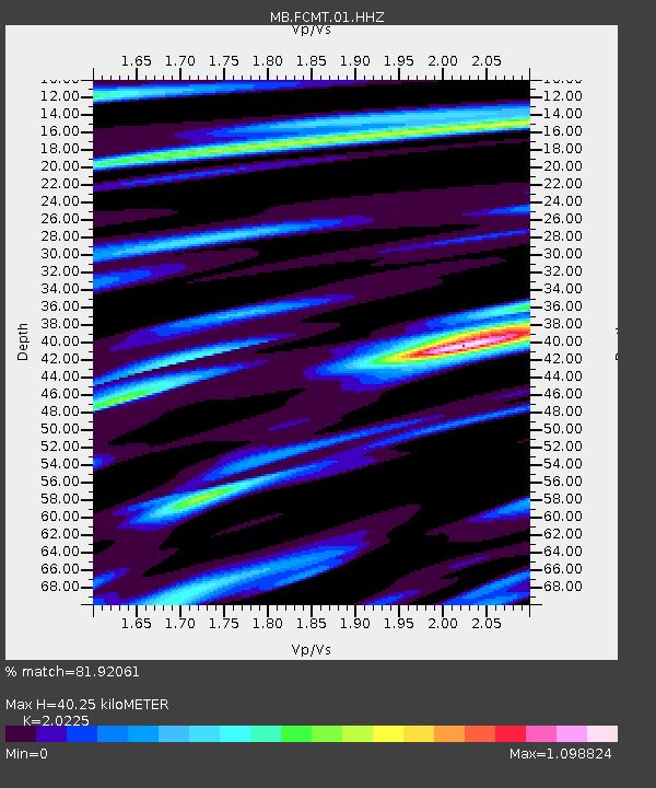
| Estimated Moho Depth: |
40.25 km |
| Estimated Crust Vp/Vs: |
2.02 |
| Assumed Crust Vp: |
6.306 km/s |
| Estimated Crust Vs: |
3.118 km/s |
| Estimated Crust Poisson's Ratio: |
0.34 |
|
| Radial Match: |
81.92061 % |
| Radial Bump: |
400 |
| Transverse Match: |
72.98325 % |
| Transverse Bump: |
400 |
| SOD ConfigId: |
33437571 |
| Insert Time: |
2024-02-03 16:08:28.314 +0000 |
| GWidth: |
2.5 |
| Max Bumps: |
400 |
| Tol: |
0.001 |
|

Signal To Noise
| Channel | StoN | STA | LTA |
| MB:FCMT:01:HHZ:20240120T16:00:27.439976Z | 2.7477615 | 1.1254783E-6 | 4.0959827E-7 |
| MB:FCMT:01:HHN:20240120T16:00:27.439976Z | 0.99420565 | 3.69066E-7 | 3.7121694E-7 |
| MB:FCMT:01:HHE:20240120T16:00:27.439976Z | 1.3581728 | 4.952138E-7 | 3.6461768E-7 |
| Arrivals |
| Ps | 6.7 SECOND |
| PpPs | 19 SECOND |
| PsPs/PpSs | 26 SECOND |


