You are here: Home > Network List > MB - Montana Regional Seismic Network Stations List
> Station HRY Helena York Bridge > Earthquake Result Viewer
HRY Helena York Bridge - Earthquake Result Viewer
| Earthquake location: |
Mariana Islands |
| Earthquake latitude/longitude: |
18.5/145.6 |
| Earthquake time(UTC): |
2024/01/20 (020) 15:48:41 GMT |
| Earthquake Depth: |
195 km |
| Earthquake Magnitude: |
6.1 mww |
| Earthquake Catalog/Contributor: |
NEIC PDE/us |
|
| Network: |
MB Montana Regional Seismic Network |
| Station: |
HRY Helena York Bridge |
| Lat/Lon: |
46.71 N/111.83 W |
| Elevation: |
1344 m |
|
| Distance: |
85.1 deg |
| Az: |
42.381 deg |
| Baz: |
291.612 deg |
| Ray Param: |
0.044576045 |
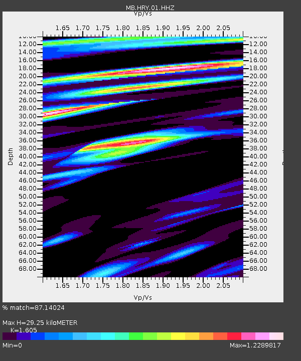
| Estimated Moho Depth: |
29.25 km |
| Estimated Crust Vp/Vs: |
1.61 |
| Assumed Crust Vp: |
6.306 km/s |
| Estimated Crust Vs: |
3.929 km/s |
| Estimated Crust Poisson's Ratio: |
0.18 |
|
| Radial Match: |
87.14024 % |
| Radial Bump: |
400 |
| Transverse Match: |
59.40595 % |
| Transverse Bump: |
400 |
| SOD ConfigId: |
33437571 |
| Insert Time: |
2024-02-03 16:08:37.666 +0000 |
| GWidth: |
2.5 |
| Max Bumps: |
400 |
| Tol: |
0.001 |
|

Signal To Noise
| Channel | StoN | STA | LTA |
| MB:HRY:01:HHZ:20240120T16:00:23.920017Z | 5.1391897 | 1.5422494E-6 | 3.0009585E-7 |
| MB:HRY:01:HHN:20240120T16:00:23.920017Z | 0.80576706 | 2.9493563E-7 | 3.660309E-7 |
| MB:HRY:01:HHE:20240120T16:00:23.920017Z | 2.27145 | 4.825899E-7 | 2.1245896E-7 |
| Arrivals |
| Ps | 2.9 SECOND |
| PpPs | 12 SECOND |
| PsPs/PpSs | 15 SECOND |


