You are here: Home > Network List > US - United States National Seismic Network Stations List
> Station HAWA Hanford, Washington, USA > Earthquake Result Viewer
HAWA Hanford, Washington, USA - Earthquake Result Viewer
*The percent match for this event was below the threshold and hence no stack was calculated.
| Earthquake location: |
Mariana Islands |
| Earthquake latitude/longitude: |
18.5/145.6 |
| Earthquake time(UTC): |
2024/01/20 (020) 15:48:41 GMT |
| Earthquake Depth: |
195 km |
| Earthquake Magnitude: |
6.1 mww |
| Earthquake Catalog/Contributor: |
NEIC PDE/us |
|
| Network: |
US United States National Seismic Network |
| Station: |
HAWA Hanford, Washington, USA |
| Lat/Lon: |
46.39 N/119.53 W |
| Elevation: |
364 m |
|
| Distance: |
80.1 deg |
| Az: |
44.424 deg |
| Baz: |
286.298 deg |
| Ray Param: |
$rayparam |
*The percent match for this event was below the threshold and hence was not used in the summary stack. |
|
| Radial Match: |
58.068943 % |
| Radial Bump: |
400 |
| Transverse Match: |
48.12264 % |
| Transverse Bump: |
400 |
| SOD ConfigId: |
33437571 |
| Insert Time: |
2024-02-03 16:15:17.944 +0000 |
| GWidth: |
2.5 |
| Max Bumps: |
400 |
| Tol: |
0.001 |
|
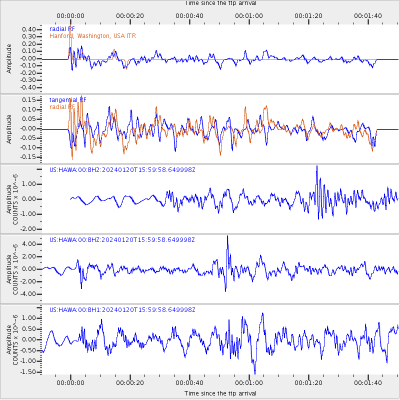
Signal To Noise
| Channel | StoN | STA | LTA |
| US:HAWA:00:BHZ:20240120T15:59:58.649998Z | 2.669551 | 9.573907E-7 | 3.5863363E-7 |
| US:HAWA:00:BH1:20240120T15:59:58.649998Z | 0.71419847 | 2.0215934E-7 | 2.8305763E-7 |
| US:HAWA:00:BH2:20240120T15:59:58.649998Z | 1.6339412 | 3.160802E-7 | 1.9344648E-7 |
| Arrivals |
| Ps | |
| PpPs | |
| PsPs/PpSs | |


