You are here: Home > Network List > UU - University of Utah Regional Network Stations List
> Station CCUT Cedar City, UT, USA > Earthquake Result Viewer
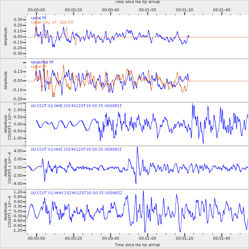
CCUT Cedar City, UT, USA - Earthquake Result Viewer
*The percent match for this event was below the threshold and hence no stack was calculated.
| Earthquake location: |
Mariana Islands |
| Earthquake latitude/longitude: |
18.5/145.6 |
| Earthquake time(UTC): |
2024/01/20 (020) 15:48:41 GMT |
| Earthquake Depth: |
195 km |
| Earthquake Magnitude: |
6.1 mww |
| Earthquake Catalog/Contributor: |
NEIC PDE/us |
|
| Network: |
UU University of Utah Regional Network |
| Station: |
CCUT Cedar City, UT, USA |
| Lat/Lon: |
37.55 N/113.36 W |
| Elevation: |
2127 m |
|
| Distance: |
87.3 deg |
| Az: |
51.339 deg |
| Baz: |
291.18 deg |
| Ray Param: |
$rayparam |
*The percent match for this event was below the threshold and hence was not used in the summary stack. |
|
| Radial Match: |
73.21933 % |
| Radial Bump: |
400 |
| Transverse Match: |
65.29461 % |
| Transverse Bump: |
400 |
| SOD ConfigId: |
33437571 |
| Insert Time: |
2024-02-03 16:15:38.599 +0000 |
| GWidth: |
2.5 |
| Max Bumps: |
400 |
| Tol: |
0.001 |
|
Signal To Noise
| Channel | StoN | STA | LTA |
| UU:CCUT:01:HHZ:20240120T16:00:35.009983Z | 3.3874078 | 1.1410464E-6 | 3.3684944E-7 |
| UU:CCUT:01:HHN:20240120T16:00:35.009983Z | 1.2016146 | 3.9936694E-7 | 3.323586E-7 |
| UU:CCUT:01:HHE:20240120T16:00:35.009983Z | 2.3016095 | 3.8412333E-7 | 1.6689334E-7 |
| Arrivals |
| Ps | |
| PpPs | |
| PsPs/PpSs | |


