You are here: Home > Network List > UU - University of Utah Regional Network Stations List
> Station FSB1 FORGE surface borehole 1, UT, USA > Earthquake Result Viewer
FSB1 FORGE surface borehole 1, UT, USA - Earthquake Result Viewer
| Earthquake location: |
Mariana Islands |
| Earthquake latitude/longitude: |
18.5/145.6 |
| Earthquake time(UTC): |
2024/01/20 (020) 15:48:41 GMT |
| Earthquake Depth: |
195 km |
| Earthquake Magnitude: |
6.1 mww |
| Earthquake Catalog/Contributor: |
NEIC PDE/us |
|
| Network: |
UU University of Utah Regional Network |
| Station: |
FSB1 FORGE surface borehole 1, UT, USA |
| Lat/Lon: |
38.48 N/112.89 W |
| Elevation: |
1697 m |
|
| Distance: |
87.3 deg |
| Az: |
50.333 deg |
| Baz: |
291.423 deg |
| Ray Param: |
0.042940117 |
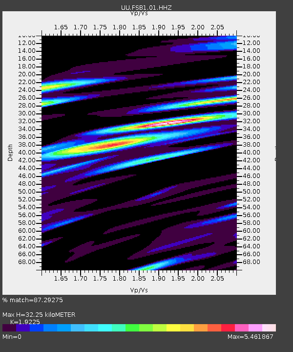
| Estimated Moho Depth: |
32.25 km |
| Estimated Crust Vp/Vs: |
1.92 |
| Assumed Crust Vp: |
6.276 km/s |
| Estimated Crust Vs: |
3.264 km/s |
| Estimated Crust Poisson's Ratio: |
0.31 |
|
| Radial Match: |
87.29275 % |
| Radial Bump: |
400 |
| Transverse Match: |
73.09619 % |
| Transverse Bump: |
400 |
| SOD ConfigId: |
33437571 |
| Insert Time: |
2024-02-03 16:15:49.684 +0000 |
| GWidth: |
2.5 |
| Max Bumps: |
400 |
| Tol: |
0.001 |
|

Signal To Noise
| Channel | StoN | STA | LTA |
| UU:FSB1:01:HHZ:20240120T16:00:35.040012Z | 2.9630232 | 3.3734742E-7 | 1.13852444E-7 |
| UU:FSB1:01:HH1:20240120T16:00:35.040012Z | 1.7300178 | 6.333276E-7 | 3.6608154E-7 |
| UU:FSB1:01:HH2:20240120T16:00:35.040012Z | 2.8432002 | 7.1428076E-7 | 2.5122424E-7 |
| Arrivals |
| Ps | 4.8 SECOND |
| PpPs | 15 SECOND |
| PsPs/PpSs | 20 SECOND |


