You are here: Home > Network List > US - United States National Seismic Network Stations List
> Station DGMT Dagmar, Montana, USA > Earthquake Result Viewer
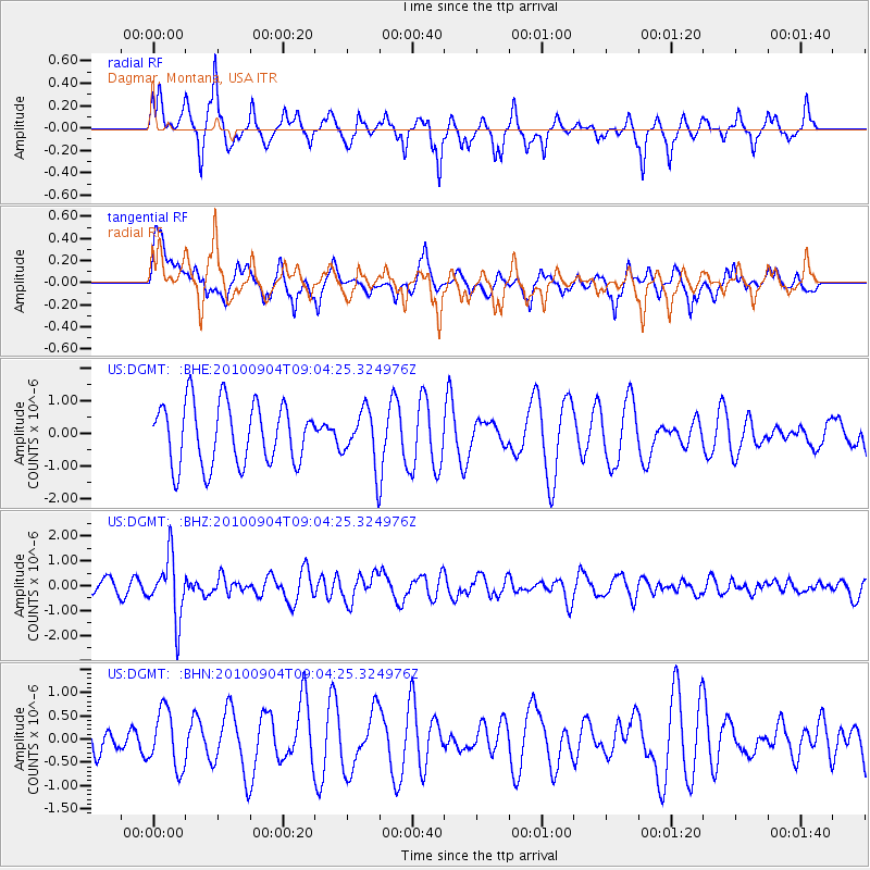
DGMT Dagmar, Montana, USA - Earthquake Result Viewer
*The percent match for this event was below the threshold and hence no stack was calculated.
| Earthquake location: |
Tonga Islands |
| Earthquake latitude/longitude: |
-17.4/-174.0 |
| Earthquake time(UTC): |
2010/09/04 (247) 08:52:04 GMT |
| Earthquake Depth: |
69 km |
| Earthquake Magnitude: |
5.9 MB, 6.1 MW, 6.0 MW |
| Earthquake Catalog/Contributor: |
WHDF/NEIC |
|
| Network: |
US United States National Seismic Network |
| Station: |
DGMT Dagmar, Montana, USA |
| Lat/Lon: |
48.47 N/104.20 W |
| Elevation: |
0.0 m |
|
| Distance: |
90.1 deg |
| Az: |
38.652 deg |
| Baz: |
243.671 deg |
| Ray Param: |
$rayparam |
*The percent match for this event was below the threshold and hence was not used in the summary stack. |
|
| Radial Match: |
61.73424 % |
| Radial Bump: |
350 |
| Transverse Match: |
40.199608 % |
| Transverse Bump: |
400 |
| SOD ConfigId: |
319893 |
| Insert Time: |
2011-01-13 08:28:56.480 +0000 |
| GWidth: |
2.5 |
| Max Bumps: |
400 |
| Tol: |
0.001 |
|
Signal To Noise
| Channel | StoN | STA | LTA |
| US:DGMT: :BHZ:20100904T09:04:25.324976Z | 2.649926 | 1.2349636E-6 | 4.6603702E-7 |
| US:DGMT: :BHN:20100904T09:04:25.324976Z | 0.8205564 | 6.174731E-7 | 7.5250546E-7 |
| US:DGMT: :BHE:20100904T09:04:25.324976Z | 0.8857883 | 8.2780394E-7 | 9.345392E-7 |
| Arrivals |
| Ps | |
| PpPs | |
| PsPs/PpSs | |


