You are here: Home > Network List > US - United States National Seismic Network Stations List
> Station AMTX Amarillo, Texas, USA > Earthquake Result Viewer
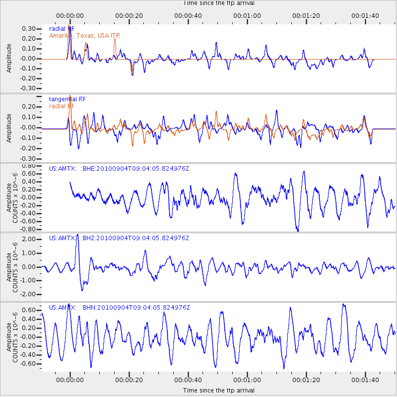
AMTX Amarillo, Texas, USA - Earthquake Result Viewer
*The percent match for this event was below the threshold and hence no stack was calculated.
| Earthquake location: |
Tonga Islands |
| Earthquake latitude/longitude: |
-17.4/-174.0 |
| Earthquake time(UTC): |
2010/09/04 (247) 08:52:04 GMT |
| Earthquake Depth: |
69 km |
| Earthquake Magnitude: |
5.9 MB, 6.1 MW, 6.0 MW |
| Earthquake Catalog/Contributor: |
WHDF/NEIC |
|
| Network: |
US United States National Seismic Network |
| Station: |
AMTX Amarillo, Texas, USA |
| Lat/Lon: |
34.53 N/101.41 W |
| Elevation: |
1010 m |
|
| Distance: |
86.1 deg |
| Az: |
52.151 deg |
| Baz: |
245.976 deg |
| Ray Param: |
$rayparam |
*The percent match for this event was below the threshold and hence was not used in the summary stack. |
|
| Radial Match: |
65.83081 % |
| Radial Bump: |
352 |
| Transverse Match: |
51.07512 % |
| Transverse Bump: |
351 |
| SOD ConfigId: |
319893 |
| Insert Time: |
2011-01-13 08:28:59.199 +0000 |
| GWidth: |
2.5 |
| Max Bumps: |
400 |
| Tol: |
0.001 |
|
Signal To Noise
| Channel | StoN | STA | LTA |
| US:AMTX: :BHZ:20100904T09:04:05.824976Z | 8.047302 | 1.1414122E-6 | 1.4183786E-7 |
| US:AMTX: :BHN:20100904T09:04:05.824976Z | 1.1493126 | 3.778959E-7 | 3.288017E-7 |
| US:AMTX: :BHE:20100904T09:04:05.824976Z | 2.405439 | 3.132092E-7 | 1.3020876E-7 |
| Arrivals |
| Ps | |
| PpPs | |
| PsPs/PpSs | |


