You are here: Home > Network List > GS - US Geological Survey Networks Stations List
> Station ASA4 ASA4 > Earthquake Result Viewer
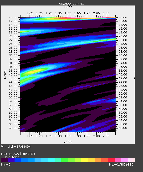
ASA4 ASA4 - Earthquake Result Viewer
| Earthquake location: |
Western Brazil |
| Earthquake latitude/longitude: |
-7.3/-71.5 |
| Earthquake time(UTC): |
2024/01/20 (020) 21:31:07 GMT |
| Earthquake Depth: |
629 km |
| Earthquake Magnitude: |
6.5 Mww |
| Earthquake Catalog/Contributor: |
NEIC PDE/us |
|
| Network: |
GS US Geological Survey Networks |
| Station: |
ASA4 ASA4 |
| Lat/Lon: |
34.94 N/106.46 W |
| Elevation: |
1820 m |
|
| Distance: |
53.4 deg |
| Az: |
324.123 deg |
| Baz: |
134.957 deg |
| Ray Param: |
0.0632639 |
| Estimated Moho Depth: |
10.0 km |
| Estimated Crust Vp/Vs: |
1.93 |
| Assumed Crust Vp: |
6.502 km/s |
| Estimated Crust Vs: |
3.364 km/s |
| Estimated Crust Poisson's Ratio: |
0.32 |
|
| Radial Match: |
87.64454 % |
| Radial Bump: |
400 |
| Transverse Match: |
63.21527 % |
| Transverse Bump: |
400 |
| SOD ConfigId: |
33437571 |
| Insert Time: |
2024-02-03 21:49:34.357 +0000 |
| GWidth: |
2.5 |
| Max Bumps: |
400 |
| Tol: |
0.001 |
|

Signal To Noise
| Channel | StoN | STA | LTA |
| GS:ASA4:00:HHZ:20240120T21:38:59.479013Z | 10.191255 | 2.0609234E-6 | 2.0222468E-7 |
| GS:ASA4:00:HH1:20240120T21:38:59.479013Z | 5.5876 | 9.4563285E-7 | 1.6923775E-7 |
| GS:ASA4:00:HH2:20240120T21:38:59.479013Z | 4.968073 | 7.511417E-7 | 1.5119379E-7 |
| Arrivals |
| Ps | 1.5 SECOND |
| PpPs | 4.3 SECOND |
| PsPs/PpSs | 5.8 SECOND |


