You are here: Home > Network List > N4 - Central and EAstern US Network Stations List
> Station BGNE Belgrade, NE, USA > Earthquake Result Viewer
BGNE Belgrade, NE, USA - Earthquake Result Viewer
| Earthquake location: |
Western Brazil |
| Earthquake latitude/longitude: |
-7.3/-71.5 |
| Earthquake time(UTC): |
2024/01/20 (020) 21:31:07 GMT |
| Earthquake Depth: |
629 km |
| Earthquake Magnitude: |
6.5 Mww |
| Earthquake Catalog/Contributor: |
NEIC PDE/us |
|
| Network: |
N4 Central and EAstern US Network |
| Station: |
BGNE Belgrade, NE, USA |
| Lat/Lon: |
41.41 N/98.15 W |
| Elevation: |
573 m |
|
| Distance: |
54.3 deg |
| Az: |
335.456 deg |
| Baz: |
146.785 deg |
| Ray Param: |
0.06272486 |
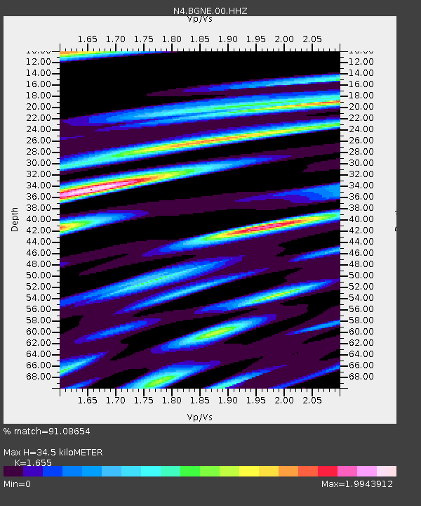
| Estimated Moho Depth: |
34.5 km |
| Estimated Crust Vp/Vs: |
1.65 |
| Assumed Crust Vp: |
6.53 km/s |
| Estimated Crust Vs: |
3.946 km/s |
| Estimated Crust Poisson's Ratio: |
0.21 |
|
| Radial Match: |
91.08654 % |
| Radial Bump: |
400 |
| Transverse Match: |
76.80469 % |
| Transverse Bump: |
400 |
| SOD ConfigId: |
33437571 |
| Insert Time: |
2024-02-03 21:53:00.095 +0000 |
| GWidth: |
2.5 |
| Max Bumps: |
400 |
| Tol: |
0.001 |
|

Signal To Noise
| Channel | StoN | STA | LTA |
| N4:BGNE:00:HHZ:20240120T21:39:05.529Z | 31.183004 | 9.267961E-6 | 2.9721193E-7 |
| N4:BGNE:00:HH1:20240120T21:39:05.529Z | 11.101033 | 4.484519E-6 | 4.0397313E-7 |
| N4:BGNE:00:HH2:20240120T21:39:05.529Z | 11.015377 | 4.301363E-6 | 3.9048714E-7 |
| Arrivals |
| Ps | 3.7 SECOND |
| PpPs | 13 SECOND |
| PsPs/PpSs | 17 SECOND |


