You are here: Home > Network List > NM - Cooperative New Madrid Seismic Network Stations List
> Station HENM Henderson Mound,MO > Earthquake Result Viewer
HENM Henderson Mound,MO - Earthquake Result Viewer
| Earthquake location: |
Western Brazil |
| Earthquake latitude/longitude: |
-7.3/-71.5 |
| Earthquake time(UTC): |
2024/01/20 (020) 21:31:07 GMT |
| Earthquake Depth: |
629 km |
| Earthquake Magnitude: |
6.5 Mww |
| Earthquake Catalog/Contributor: |
NEIC PDE/us |
|
| Network: |
NM Cooperative New Madrid Seismic Network |
| Station: |
HENM Henderson Mound,MO |
| Lat/Lon: |
36.72 N/89.47 W |
| Elevation: |
88 m |
|
| Distance: |
46.9 deg |
| Az: |
340.167 deg |
| Baz: |
155.239 deg |
| Ray Param: |
0.06720754 |
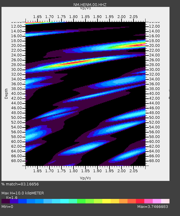
| Estimated Moho Depth: |
10.0 km |
| Estimated Crust Vp/Vs: |
1.60 |
| Assumed Crust Vp: |
6.444 km/s |
| Estimated Crust Vs: |
4.027 km/s |
| Estimated Crust Poisson's Ratio: |
0.18 |
|
| Radial Match: |
83.16656 % |
| Radial Bump: |
400 |
| Transverse Match: |
74.392586 % |
| Transverse Bump: |
400 |
| SOD ConfigId: |
33437571 |
| Insert Time: |
2024-02-03 21:56:17.899 +0000 |
| GWidth: |
2.5 |
| Max Bumps: |
400 |
| Tol: |
0.001 |
|

Signal To Noise
| Channel | StoN | STA | LTA |
| NM:HENM:00:HHZ:20240120T21:38:12.44999Z | 8.137805 | 3.939552E-6 | 4.8410493E-7 |
| NM:HENM:00:HHN:20240120T21:38:12.44999Z | 4.798503 | 4.1536196E-6 | 8.656074E-7 |
| NM:HENM:00:HHE:20240120T21:38:12.44999Z | 4.2378163 | 3.553238E-6 | 8.384597E-7 |
| Arrivals |
| Ps | 1.0 SECOND |
| PpPs | 3.8 SECOND |
| PsPs/PpSs | 4.8 SECOND |


