You are here: Home > Network List > TA - USArray Transportable Network (new EarthScope stations) Stations List
> Station J26A Sides Ranch, Smithwick, SD, USA > Earthquake Result Viewer
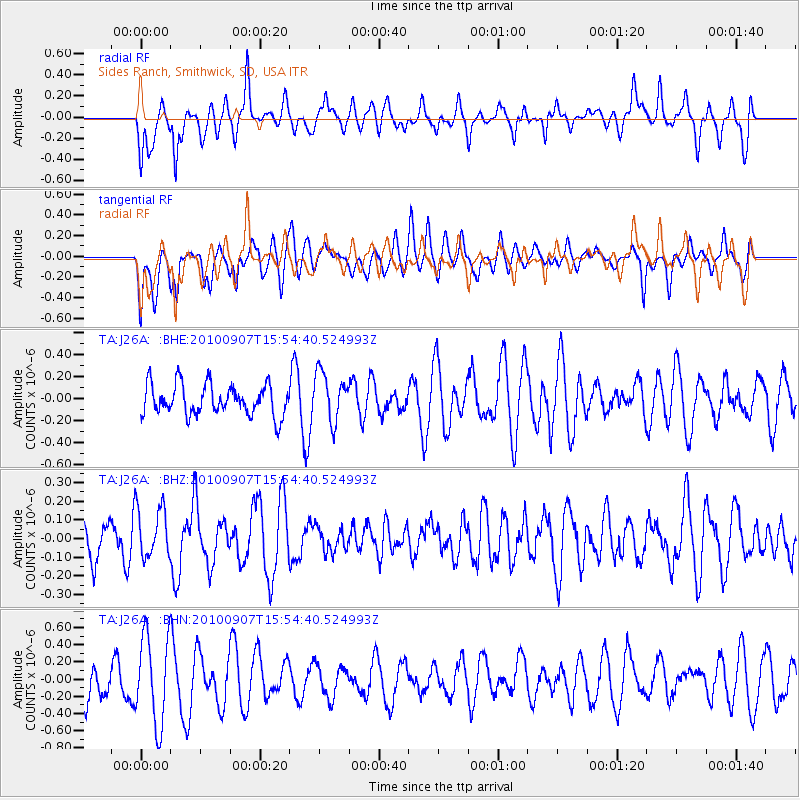
J26A Sides Ranch, Smithwick, SD, USA - Earthquake Result Viewer
*The percent match for this event was below the threshold and hence no stack was calculated.
| Earthquake location: |
Tajikistan-Xinjiang Border Reg. |
| Earthquake latitude/longitude: |
39.5/73.8 |
| Earthquake time(UTC): |
2010/09/07 (250) 15:41:37 GMT |
| Earthquake Depth: |
10 km |
| Earthquake Magnitude: |
5.5 MB, 5.2 MS, 5.3 MW, 5.2 MW |
| Earthquake Catalog/Contributor: |
WHDF/NEIC |
|
| Network: |
TA USArray Transportable Network (new EarthScope stations) |
| Station: |
J26A Sides Ranch, Smithwick, SD, USA |
| Lat/Lon: |
43.31 N/103.08 W |
| Elevation: |
993 m |
|
| Distance: |
97.6 deg |
| Az: |
357.729 deg |
| Baz: |
2.409 deg |
| Ray Param: |
$rayparam |
*The percent match for this event was below the threshold and hence was not used in the summary stack. |
|
| Radial Match: |
54.422348 % |
| Radial Bump: |
377 |
| Transverse Match: |
58.946053 % |
| Transverse Bump: |
400 |
| SOD ConfigId: |
319893 |
| Insert Time: |
2011-01-13 08:48:11.504 +0000 |
| GWidth: |
2.5 |
| Max Bumps: |
400 |
| Tol: |
0.001 |
|
Signal To Noise
| Channel | StoN | STA | LTA |
| TA:J26A: :BHZ:20100907T15:54:40.524993Z | 1.175018 | 1.3612892E-7 | 1.15852636E-7 |
| TA:J26A: :BHN:20100907T15:54:40.524993Z | 1.8702416 | 5.1513774E-7 | 2.754391E-7 |
| TA:J26A: :BHE:20100907T15:54:40.524993Z | 1.606068 | 2.2407292E-7 | 1.3951646E-7 |
| Arrivals |
| Ps | |
| PpPs | |
| PsPs/PpSs | |


