You are here: Home > Network List > TX - Texas Seismological Network Stations List
> Station PB37 UTL Block 46 > Earthquake Result Viewer
PB37 UTL Block 46 - Earthquake Result Viewer
| Earthquake location: |
Western Brazil |
| Earthquake latitude/longitude: |
-7.3/-71.5 |
| Earthquake time(UTC): |
2024/01/20 (020) 21:31:07 GMT |
| Earthquake Depth: |
629 km |
| Earthquake Magnitude: |
6.5 Mww |
| Earthquake Catalog/Contributor: |
NEIC PDE/us |
|
| Network: |
TX Texas Seismological Network |
| Station: |
PB37 UTL Block 46 |
| Lat/Lon: |
31.72 N/104.53 W |
| Elevation: |
1263 m |
|
| Distance: |
50.0 deg |
| Az: |
322.689 deg |
| Baz: |
135.127 deg |
| Ray Param: |
0.06534193 |
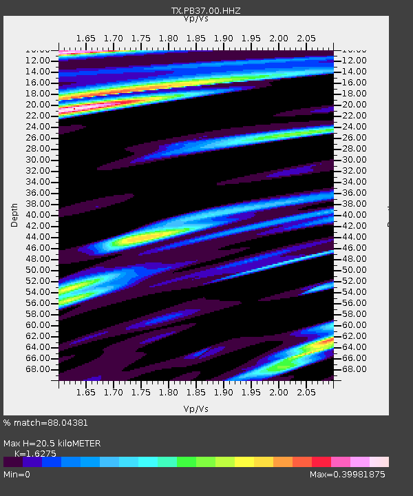
| Estimated Moho Depth: |
20.5 km |
| Estimated Crust Vp/Vs: |
1.63 |
| Assumed Crust Vp: |
6.361 km/s |
| Estimated Crust Vs: |
3.908 km/s |
| Estimated Crust Poisson's Ratio: |
0.20 |
|
| Radial Match: |
88.04381 % |
| Radial Bump: |
317 |
| Transverse Match: |
74.79192 % |
| Transverse Bump: |
400 |
| SOD ConfigId: |
33437571 |
| Insert Time: |
2024-02-03 22:04:48.237 +0000 |
| GWidth: |
2.5 |
| Max Bumps: |
400 |
| Tol: |
0.001 |
|

Signal To Noise
| Channel | StoN | STA | LTA |
| TX:PB37:00:HHZ:20240120T21:38:35.109994Z | 23.003315 | 5.2388564E-6 | 2.2774354E-7 |
| TX:PB37:00:HH1:20240120T21:38:35.109994Z | 5.747302 | 1.5172521E-6 | 2.639938E-7 |
| TX:PB37:00:HH2:20240120T21:38:35.109994Z | 6.2862654 | 1.3788815E-6 | 2.193483E-7 |
| Arrivals |
| Ps | 2.1 SECOND |
| PpPs | 8.0 SECOND |
| PsPs/PpSs | 10 SECOND |


