You are here: Home > Network List > US - United States National Seismic Network Stations List
> Station ELK Elko, Nevada, USA > Earthquake Result Viewer
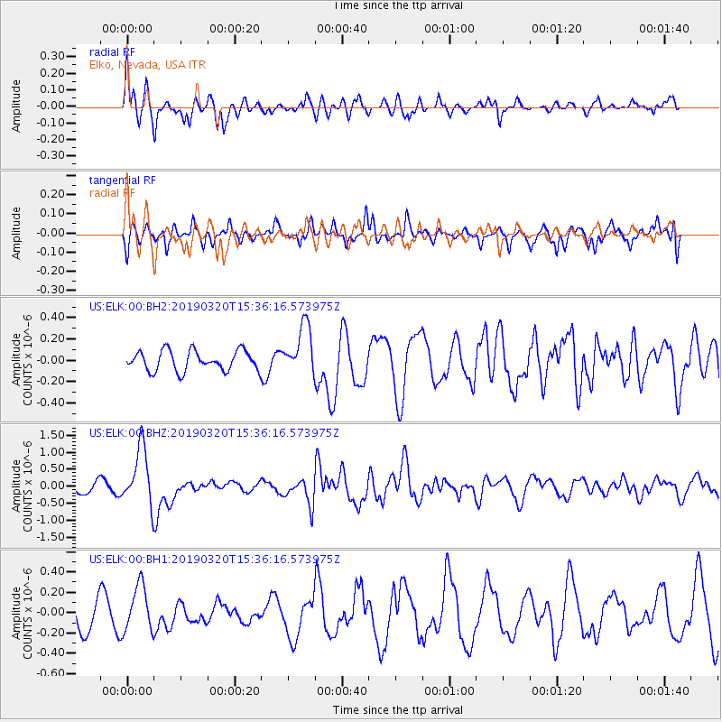
ELK Elko, Nevada, USA - Earthquake Result Viewer
*The percent match for this event was below the threshold and hence no stack was calculated.
| Earthquake location: |
Vanuatu Islands |
| Earthquake latitude/longitude: |
-15.6/167.6 |
| Earthquake time(UTC): |
2019/03/20 (079) 15:23:59 GMT |
| Earthquake Depth: |
125 km |
| Earthquake Magnitude: |
6.2 Mww |
| Earthquake Catalog/Contributor: |
NEIC PDE/us |
|
| Network: |
US United States National Seismic Network |
| Station: |
ELK Elko, Nevada, USA |
| Lat/Lon: |
40.74 N/115.24 W |
| Elevation: |
2210 m |
|
| Distance: |
90.6 deg |
| Az: |
47.801 deg |
| Baz: |
249.963 deg |
| Ray Param: |
$rayparam |
*The percent match for this event was below the threshold and hence was not used in the summary stack. |
|
| Radial Match: |
74.496124 % |
| Radial Bump: |
342 |
| Transverse Match: |
53.14068 % |
| Transverse Bump: |
341 |
| SOD ConfigId: |
3338192 |
| Insert Time: |
2019-04-03 15:28:49.517 +0000 |
| GWidth: |
2.5 |
| Max Bumps: |
400 |
| Tol: |
0.001 |
|
Signal To Noise
| Channel | StoN | STA | LTA |
| US:ELK:00:BHZ:20190320T15:36:16.573975Z | 6.888008 | 8.635996E-7 | 1.2537727E-7 |
| US:ELK:00:BH1:20190320T15:36:16.573975Z | 1.1047317 | 2.292459E-7 | 2.0751274E-7 |
| US:ELK:00:BH2:20190320T15:36:16.573975Z | 2.524936 | 2.349976E-7 | 9.307072E-8 |
| Arrivals |
| Ps | |
| PpPs | |
| PsPs/PpSs | |


