You are here: Home > Network List > US - United States National Seismic Network Stations List
> Station HAWA Hanford, Washington, USA > Earthquake Result Viewer
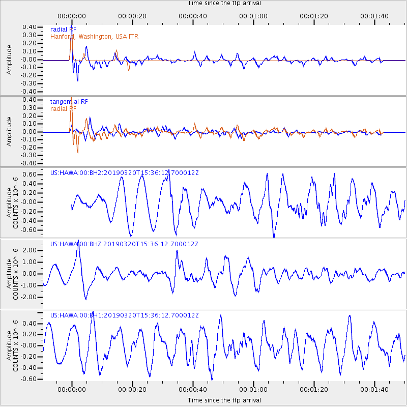
HAWA Hanford, Washington, USA - Earthquake Result Viewer
*The percent match for this event was below the threshold and hence no stack was calculated.
| Earthquake location: |
Vanuatu Islands |
| Earthquake latitude/longitude: |
-15.6/167.6 |
| Earthquake time(UTC): |
2019/03/20 (079) 15:23:59 GMT |
| Earthquake Depth: |
125 km |
| Earthquake Magnitude: |
6.2 Mww |
| Earthquake Catalog/Contributor: |
NEIC PDE/us |
|
| Network: |
US United States National Seismic Network |
| Station: |
HAWA Hanford, Washington, USA |
| Lat/Lon: |
46.39 N/119.53 W |
| Elevation: |
364 m |
|
| Distance: |
89.8 deg |
| Az: |
41.407 deg |
| Baz: |
247.034 deg |
| Ray Param: |
$rayparam |
*The percent match for this event was below the threshold and hence was not used in the summary stack. |
|
| Radial Match: |
76.41703 % |
| Radial Bump: |
400 |
| Transverse Match: |
79.98133 % |
| Transverse Bump: |
400 |
| SOD ConfigId: |
3338192 |
| Insert Time: |
2019-04-03 15:28:50.879 +0000 |
| GWidth: |
2.5 |
| Max Bumps: |
400 |
| Tol: |
0.001 |
|
Signal To Noise
| Channel | StoN | STA | LTA |
| US:HAWA:00:BHZ:20190320T15:36:12.700012Z | 2.8108072 | 1.4451654E-6 | 5.1414605E-7 |
| US:HAWA:00:BH1:20190320T15:36:12.700012Z | 1.7806039 | 3.203212E-7 | 1.798947E-7 |
| US:HAWA:00:BH2:20190320T15:36:12.700012Z | 1.5106926 | 4.5677595E-7 | 3.0236194E-7 |
| Arrivals |
| Ps | |
| PpPs | |
| PsPs/PpSs | |


