You are here: Home > Network List > US - United States National Seismic Network Stations List
> Station CBKS Cedar Bluff, Kansas, USA > Earthquake Result Viewer
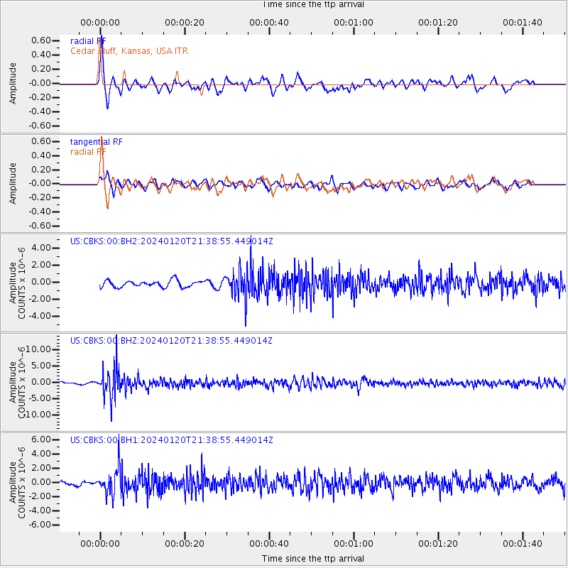
CBKS Cedar Bluff, Kansas, USA - Earthquake Result Viewer
*The percent match for this event was below the threshold and hence no stack was calculated.
| Earthquake location: |
Western Brazil |
| Earthquake latitude/longitude: |
-7.3/-71.5 |
| Earthquake time(UTC): |
2024/01/20 (020) 21:31:07 GMT |
| Earthquake Depth: |
629 km |
| Earthquake Magnitude: |
6.5 Mww |
| Earthquake Catalog/Contributor: |
NEIC PDE/us |
|
| Network: |
US United States National Seismic Network |
| Station: |
CBKS Cedar Bluff, Kansas, USA |
| Lat/Lon: |
38.81 N/99.74 W |
| Elevation: |
677 m |
|
| Distance: |
52.9 deg |
| Az: |
332.381 deg |
| Baz: |
143.94 deg |
| Ray Param: |
$rayparam |
*The percent match for this event was below the threshold and hence was not used in the summary stack. |
|
| Radial Match: |
69.88448 % |
| Radial Bump: |
400 |
| Transverse Match: |
59.289272 % |
| Transverse Bump: |
400 |
| SOD ConfigId: |
33437571 |
| Insert Time: |
2024-02-03 22:06:54.458 +0000 |
| GWidth: |
2.5 |
| Max Bumps: |
400 |
| Tol: |
0.001 |
|
Signal To Noise
| Channel | StoN | STA | LTA |
| US:CBKS:00:BHZ:20240120T21:38:55.449014Z | 16.350033 | 4.406507E-6 | 2.6951056E-7 |
| US:CBKS:00:BH1:20240120T21:38:55.449014Z | 4.920672 | 1.8031162E-6 | 3.66437E-7 |
| US:CBKS:00:BH2:20240120T21:38:55.449014Z | 3.9614036 | 1.5175153E-6 | 3.8307513E-7 |
| Arrivals |
| Ps | |
| PpPs | |
| PsPs/PpSs | |


