You are here: Home > Network List > US - United States National Seismic Network Stations List
> Station MSO Missoula, Montana, USA > Earthquake Result Viewer
MSO Missoula, Montana, USA - Earthquake Result Viewer
*The percent match for this event was below the threshold and hence no stack was calculated.
| Earthquake location: |
Western Brazil |
| Earthquake latitude/longitude: |
-7.3/-71.5 |
| Earthquake time(UTC): |
2024/01/20 (020) 21:31:07 GMT |
| Earthquake Depth: |
629 km |
| Earthquake Magnitude: |
6.5 Mww |
| Earthquake Catalog/Contributor: |
NEIC PDE/us |
|
| Network: |
US United States National Seismic Network |
| Station: |
MSO Missoula, Montana, USA |
| Lat/Lon: |
46.83 N/113.94 W |
| Elevation: |
1264 m |
|
| Distance: |
65.8 deg |
| Az: |
329.461 deg |
| Baz: |
132.77 deg |
| Ray Param: |
$rayparam |
*The percent match for this event was below the threshold and hence was not used in the summary stack. |
|
| Radial Match: |
56.75787 % |
| Radial Bump: |
400 |
| Transverse Match: |
46.088333 % |
| Transverse Bump: |
400 |
| SOD ConfigId: |
33437571 |
| Insert Time: |
2024-02-03 22:07:31.201 +0000 |
| GWidth: |
2.5 |
| Max Bumps: |
400 |
| Tol: |
0.001 |
|
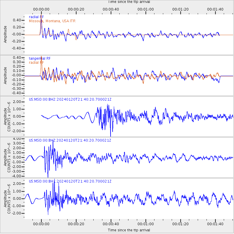
Signal To Noise
| Channel | StoN | STA | LTA |
| US:MSO:00:BHZ:20240120T21:40:20.700021Z | 4.3218417 | 1.6185046E-6 | 3.7449416E-7 |
| US:MSO:00:BH1:20240120T21:40:20.700021Z | 1.4592155 | 6.366911E-7 | 4.363242E-7 |
| US:MSO:00:BH2:20240120T21:40:20.700021Z | 5.1836457 | 7.566905E-7 | 1.459765E-7 |
| Arrivals |
| Ps | |
| PpPs | |
| PsPs/PpSs | |


