You are here: Home > Network List > TM - Thai Seismic Monitoring Network Stations List
> Station PANO PANO staion > Earthquake Result Viewer
PANO PANO staion - Earthquake Result Viewer
| Earthquake location: |
Southwest Indian Ridge |
| Earthquake latitude/longitude: |
-39.9/46.1 |
| Earthquake time(UTC): |
2024/01/20 (020) 22:09:40 GMT |
| Earthquake Depth: |
10 km |
| Earthquake Magnitude: |
6.3 mww |
| Earthquake Catalog/Contributor: |
NEIC PDE/us |
|
| Network: |
TM Thai Seismic Monitoring Network |
| Station: |
PANO PANO staion |
| Lat/Lon: |
17.15 N/104.61 E |
| Elevation: |
136 m |
|
| Distance: |
78.6 deg |
| Az: |
56.246 deg |
| Baz: |
221.972 deg |
| Ray Param: |
0.0495067 |
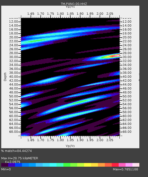
| Estimated Moho Depth: |
28.75 km |
| Estimated Crust Vp/Vs: |
2.10 |
| Assumed Crust Vp: |
6.498 km/s |
| Estimated Crust Vs: |
3.098 km/s |
| Estimated Crust Poisson's Ratio: |
0.35 |
|
| Radial Match: |
84.44274 % |
| Radial Bump: |
400 |
| Transverse Match: |
76.51429 % |
| Transverse Bump: |
400 |
| SOD ConfigId: |
33437571 |
| Insert Time: |
2024-02-03 22:19:10.442 +0000 |
| GWidth: |
2.5 |
| Max Bumps: |
400 |
| Tol: |
0.001 |
|

Signal To Noise
| Channel | StoN | STA | LTA |
| TM:PANO:00:HHZ:20240120T22:21:10.894972Z | 13.054924 | 2.341868E-7 | 1.793858E-8 |
| TM:PANO:00:HHN:20240120T22:21:10.894972Z | 1.8769215 | 3.0016125E-8 | 1.599221E-8 |
| TM:PANO:00:HHE:20240120T22:21:10.894972Z | 1.2675554 | 1.8589148E-8 | 1.4665353E-8 |
| Arrivals |
| Ps | 5.0 SECOND |
| PpPs | 13 SECOND |
| PsPs/PpSs | 18 SECOND |


