You are here: Home > Network List > 1E - GSC-BCOGC Induced Seismicity Study Stations List
> Station MONT9 Z > Earthquake Result Viewer
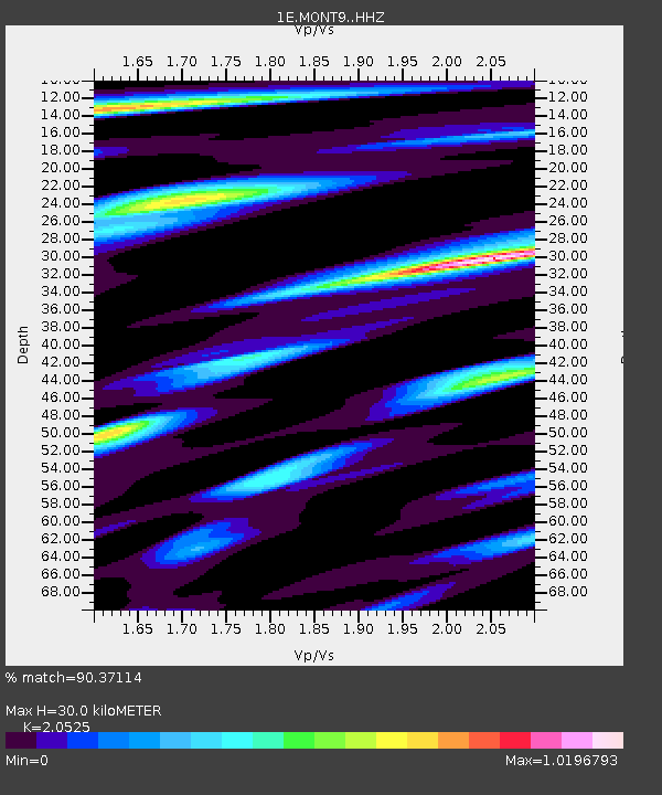
MONT9 Z - Earthquake Result Viewer
| Earthquake location: |
Kyrgyzstan-Xinjiang Border Reg. |
| Earthquake latitude/longitude: |
41.3/78.6 |
| Earthquake time(UTC): |
2024/01/22 (022) 18:09:04 GMT |
| Earthquake Depth: |
13 km |
| Earthquake Magnitude: |
7.0 Mww |
| Earthquake Catalog/Contributor: |
NEIC PDE/us |
|
| Network: |
1E GSC-BCOGC Induced Seismicity Study |
| Station: |
MONT9 Z |
| Lat/Lon: |
55.80 N/120.54 W |
| Elevation: |
832 m |
|
| Distance: |
81.9 deg |
| Az: |
10.802 deg |
| Baz: |
345.509 deg |
| Ray Param: |
0.04723727 |
| Estimated Moho Depth: |
30.0 km |
| Estimated Crust Vp/Vs: |
2.05 |
| Assumed Crust Vp: |
6.303 km/s |
| Estimated Crust Vs: |
3.071 km/s |
| Estimated Crust Poisson's Ratio: |
0.34 |
|
| Radial Match: |
90.37114 % |
| Radial Bump: |
400 |
| Transverse Match: |
73.38913 % |
| Transverse Bump: |
400 |
| SOD ConfigId: |
33437571 |
| Insert Time: |
2024-02-05 18:10:34.989 +0000 |
| GWidth: |
2.5 |
| Max Bumps: |
400 |
| Tol: |
0.001 |
|

Signal To Noise
| Channel | StoN | STA | LTA |
| 1E:MONT9: :HHZ:20240122T18:20:52.260029Z | 6.9611783 | 2.087596E-6 | 2.9989118E-7 |
| 1E:MONT9: :HHN:20240122T18:20:52.260029Z | 4.830483 | 1.0974668E-6 | 2.2719607E-7 |
| 1E:MONT9: :HHE:20240122T18:20:52.260029Z | 3.639958 | 5.638959E-7 | 1.5491825E-7 |
| Arrivals |
| Ps | 5.1 SECOND |
| PpPs | 14 SECOND |
| PsPs/PpSs | 19 SECOND |


