You are here: Home > Network List > AK - Alaska Regional Network Stations List
> Station CAST Castle Rocks > Earthquake Result Viewer
CAST Castle Rocks - Earthquake Result Viewer
| Earthquake location: |
Kyrgyzstan-Xinjiang Border Reg. |
| Earthquake latitude/longitude: |
41.3/78.6 |
| Earthquake time(UTC): |
2024/01/22 (022) 18:09:04 GMT |
| Earthquake Depth: |
13 km |
| Earthquake Magnitude: |
7.0 Mww |
| Earthquake Catalog/Contributor: |
NEIC PDE/us |
|
| Network: |
AK Alaska Regional Network |
| Station: |
CAST Castle Rocks |
| Lat/Lon: |
63.42 N/152.08 W |
| Elevation: |
611 m |
|
| Distance: |
68.1 deg |
| Az: |
22.039 deg |
| Baz: |
321.041 deg |
| Ray Param: |
0.05648908 |
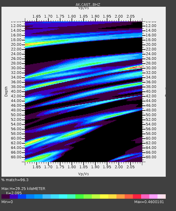
| Estimated Moho Depth: |
29.25 km |
| Estimated Crust Vp/Vs: |
2.10 |
| Assumed Crust Vp: |
6.566 km/s |
| Estimated Crust Vs: |
3.134 km/s |
| Estimated Crust Poisson's Ratio: |
0.35 |
|
| Radial Match: |
96.3 % |
| Radial Bump: |
318 |
| Transverse Match: |
80.27034 % |
| Transverse Bump: |
400 |
| SOD ConfigId: |
33437571 |
| Insert Time: |
2024-02-05 18:11:43.339 +0000 |
| GWidth: |
2.5 |
| Max Bumps: |
400 |
| Tol: |
0.001 |
|

Signal To Noise
| Channel | StoN | STA | LTA |
| AK:CAST: :BHZ:20240122T18:19:32.967976Z | 10.964781 | 2.8609031E-6 | 2.6091752E-7 |
| AK:CAST: :BHN:20240122T18:19:32.967976Z | 7.1575446 | 1.1252985E-6 | 1.5721851E-7 |
| AK:CAST: :BHE:20240122T18:19:32.967976Z | 2.2962196 | 6.2151764E-7 | 2.7066994E-7 |
| Arrivals |
| Ps | 5.0 SECOND |
| PpPs | 13 SECOND |
| PsPs/PpSs | 18 SECOND |


