You are here: Home > Network List > AU - Australian Seismological Centre Stations List
> Station KIM04 GSWA station > Earthquake Result Viewer
KIM04 GSWA station - Earthquake Result Viewer
| Earthquake location: |
Kyrgyzstan-Xinjiang Border Reg. |
| Earthquake latitude/longitude: |
41.3/78.6 |
| Earthquake time(UTC): |
2024/01/22 (022) 18:09:04 GMT |
| Earthquake Depth: |
13 km |
| Earthquake Magnitude: |
7.0 Mww |
| Earthquake Catalog/Contributor: |
NEIC PDE/us |
|
| Network: |
AU Australian Seismological Centre |
| Station: |
KIM04 GSWA station |
| Lat/Lon: |
17.93 S/124.81 E |
| Elevation: |
133 m |
|
| Distance: |
72.8 deg |
| Az: |
134.034 deg |
| Baz: |
325.303 deg |
| Ray Param: |
0.053441938 |
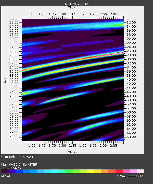
| Estimated Moho Depth: |
26.5 km |
| Estimated Crust Vp/Vs: |
2.09 |
| Assumed Crust Vp: |
6.496 km/s |
| Estimated Crust Vs: |
3.104 km/s |
| Estimated Crust Poisson's Ratio: |
0.35 |
|
| Radial Match: |
92.69528 % |
| Radial Bump: |
400 |
| Transverse Match: |
88.189766 % |
| Transverse Bump: |
400 |
| SOD ConfigId: |
33437571 |
| Insert Time: |
2024-02-05 18:15:24.813 +0000 |
| GWidth: |
2.5 |
| Max Bumps: |
400 |
| Tol: |
0.001 |
|

Signal To Noise
| Channel | StoN | STA | LTA |
| AU:KIM04: :HHZ:20240122T18:20:01.170002Z | 7.4106054 | 1.0908375E-5 | 1.4719951E-6 |
| AU:KIM04: :HHN:20240122T18:20:01.170002Z | 1.3701078 | 3.840344E-6 | 2.8029501E-6 |
| AU:KIM04: :HHE:20240122T18:20:01.170002Z | 1.8774941 | 5.4669E-6 | 2.9118069E-6 |
| Arrivals |
| Ps | 4.6 SECOND |
| PpPs | 12 SECOND |
| PsPs/PpSs | 17 SECOND |


