You are here: Home > Network List > AU - Australian Seismological Centre Stations List
> Station KIM05 GSWA station > Earthquake Result Viewer
KIM05 GSWA station - Earthquake Result Viewer
| Earthquake location: |
Kyrgyzstan-Xinjiang Border Reg. |
| Earthquake latitude/longitude: |
41.3/78.6 |
| Earthquake time(UTC): |
2024/01/22 (022) 18:09:04 GMT |
| Earthquake Depth: |
13 km |
| Earthquake Magnitude: |
7.0 Mww |
| Earthquake Catalog/Contributor: |
NEIC PDE/us |
|
| Network: |
AU Australian Seismological Centre |
| Station: |
KIM05 GSWA station |
| Lat/Lon: |
17.99 S/124.19 E |
| Elevation: |
70 m |
|
| Distance: |
72.5 deg |
| Az: |
134.582 deg |
| Baz: |
325.657 deg |
| Ray Param: |
0.053624354 |
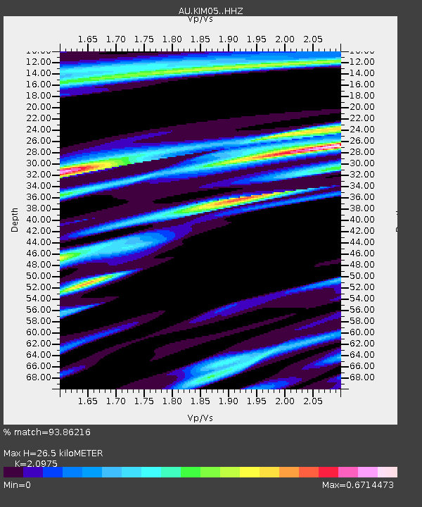
| Estimated Moho Depth: |
26.5 km |
| Estimated Crust Vp/Vs: |
2.10 |
| Assumed Crust Vp: |
6.496 km/s |
| Estimated Crust Vs: |
3.097 km/s |
| Estimated Crust Poisson's Ratio: |
0.35 |
|
| Radial Match: |
93.86216 % |
| Radial Bump: |
400 |
| Transverse Match: |
75.57655 % |
| Transverse Bump: |
400 |
| SOD ConfigId: |
33437571 |
| Insert Time: |
2024-02-05 18:15:25.692 +0000 |
| GWidth: |
2.5 |
| Max Bumps: |
400 |
| Tol: |
0.001 |
|

Signal To Noise
| Channel | StoN | STA | LTA |
| AU:KIM05: :HHZ:20240122T18:19:59.49001Z | 5.6065326 | 1.8673289E-6 | 3.3306307E-7 |
| AU:KIM05: :HHN:20240122T18:19:59.49001Z | 1.0517265 | 5.647692E-7 | 5.3699245E-7 |
| AU:KIM05: :HHE:20240122T18:19:59.49001Z | 1.342643 | 5.6754277E-7 | 4.2270563E-7 |
| Arrivals |
| Ps | 4.6 SECOND |
| PpPs | 12 SECOND |
| PsPs/PpSs | 17 SECOND |


