You are here: Home > Network List > AU - Australian Seismological Centre Stations List
> Station KIM07 GSWA station > Earthquake Result Viewer
KIM07 GSWA station - Earthquake Result Viewer
| Earthquake location: |
Kyrgyzstan-Xinjiang Border Reg. |
| Earthquake latitude/longitude: |
41.3/78.6 |
| Earthquake time(UTC): |
2024/01/22 (022) 18:09:04 GMT |
| Earthquake Depth: |
13 km |
| Earthquake Magnitude: |
7.0 Mww |
| Earthquake Catalog/Contributor: |
NEIC PDE/us |
|
| Network: |
AU Australian Seismological Centre |
| Station: |
KIM07 GSWA station |
| Lat/Lon: |
17.99 S/123.16 E |
| Elevation: |
101 m |
|
| Distance: |
71.9 deg |
| Az: |
135.432 deg |
| Baz: |
326.232 deg |
| Ray Param: |
0.05399041 |
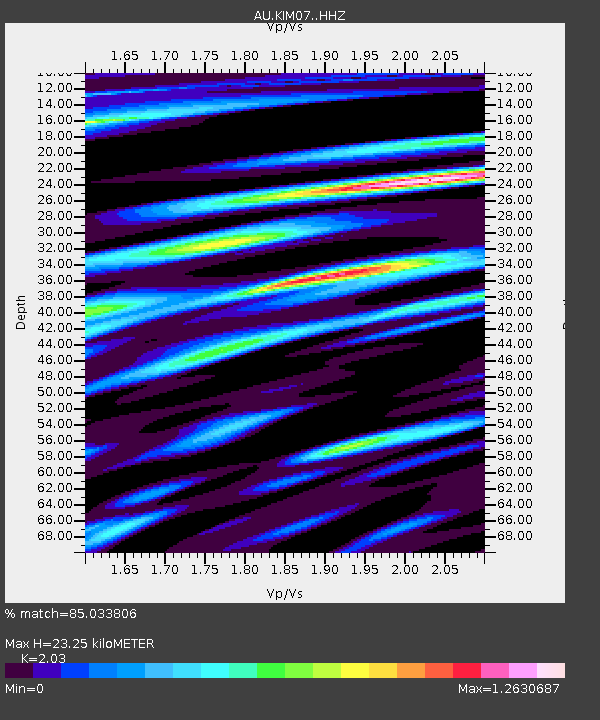
| Estimated Moho Depth: |
23.25 km |
| Estimated Crust Vp/Vs: |
2.03 |
| Assumed Crust Vp: |
6.159 km/s |
| Estimated Crust Vs: |
3.034 km/s |
| Estimated Crust Poisson's Ratio: |
0.34 |
|
| Radial Match: |
85.033806 % |
| Radial Bump: |
400 |
| Transverse Match: |
46.62573 % |
| Transverse Bump: |
400 |
| SOD ConfigId: |
33437571 |
| Insert Time: |
2024-02-05 18:15:28.690 +0000 |
| GWidth: |
2.5 |
| Max Bumps: |
400 |
| Tol: |
0.001 |
|

Signal To Noise
| Channel | StoN | STA | LTA |
| AU:KIM07: :HHZ:20240122T18:19:55.949971Z | 8.151419 | 3.3686338E-6 | 4.1325734E-7 |
| AU:KIM07: :HHN:20240122T18:19:55.949971Z | 0.8056454 | 1.8944451E-6 | 2.3514626E-6 |
| AU:KIM07: :HHE:20240122T18:19:55.949971Z | 0.8871235 | 3.1404818E-6 | 3.5400726E-6 |
| Arrivals |
| Ps | 4.0 SECOND |
| PpPs | 11 SECOND |
| PsPs/PpSs | 15 SECOND |


