You are here: Home > Network List > US - United States National Seismic Network Stations List
> Station HAWA Hanford, Washington, USA > Earthquake Result Viewer
HAWA Hanford, Washington, USA - Earthquake Result Viewer
*The percent match for this event was below the threshold and hence no stack was calculated.
| Earthquake location: |
Fiji Islands Region |
| Earthquake latitude/longitude: |
-15.9/-179.3 |
| Earthquake time(UTC): |
2010/09/07 (250) 16:13:32 GMT |
| Earthquake Depth: |
10 km |
| Earthquake Magnitude: |
5.7 MB, 6.0 MS, 6.3 MW, 6.2 MW |
| Earthquake Catalog/Contributor: |
WHDF/NEIC |
|
| Network: |
US United States National Seismic Network |
| Station: |
HAWA Hanford, Washington, USA |
| Lat/Lon: |
46.39 N/119.53 W |
| Elevation: |
364 m |
|
| Distance: |
82.0 deg |
| Az: |
37.15 deg |
| Baz: |
237.103 deg |
| Ray Param: |
$rayparam |
*The percent match for this event was below the threshold and hence was not used in the summary stack. |
|
| Radial Match: |
67.09591 % |
| Radial Bump: |
400 |
| Transverse Match: |
63.655846 % |
| Transverse Bump: |
400 |
| SOD ConfigId: |
319893 |
| Insert Time: |
2011-01-13 09:01:09.819 +0000 |
| GWidth: |
2.5 |
| Max Bumps: |
400 |
| Tol: |
0.001 |
|
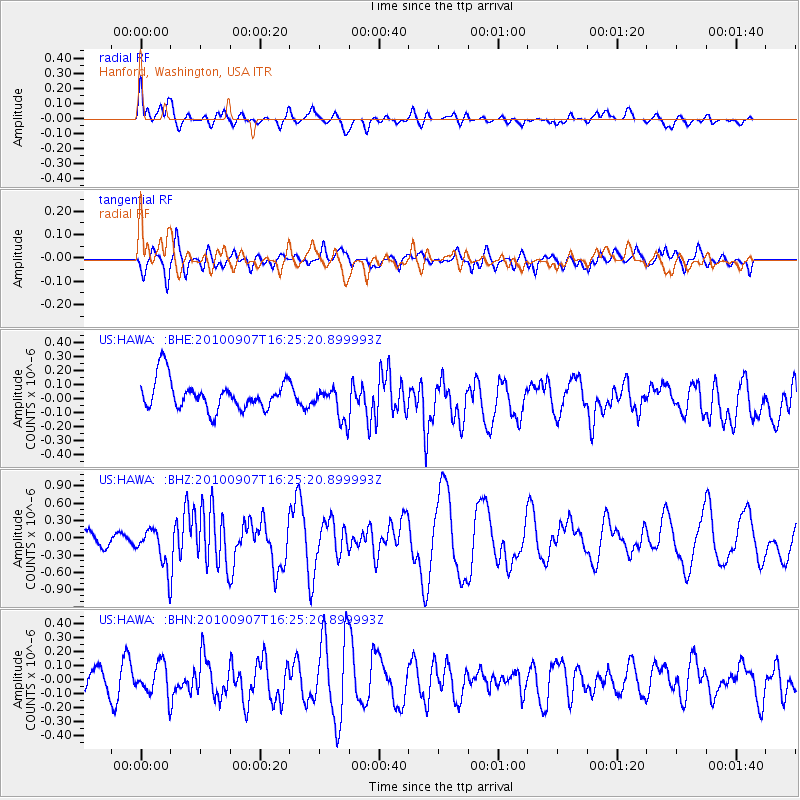
Signal To Noise
| Channel | StoN | STA | LTA |
| US:HAWA: :BHZ:20100907T16:25:20.899993Z | 2.097154 | 3.3388096E-7 | 1.592067E-7 |
| US:HAWA: :BHN:20100907T16:25:20.899993Z | 0.95229775 | 1.1075264E-7 | 1.1630043E-7 |
| US:HAWA: :BHE:20100907T16:25:20.899993Z | 1.1310081 | 1.2086359E-7 | 1.0686358E-7 |
| Arrivals |
| Ps | |
| PpPs | |
| PsPs/PpSs | |


