You are here: Home > Network List > US - United States National Seismic Network Stations List
> Station MSO Missoula, Montana, USA > Earthquake Result Viewer
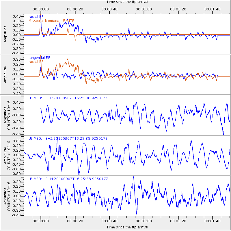
MSO Missoula, Montana, USA - Earthquake Result Viewer
*The percent match for this event was below the threshold and hence no stack was calculated.
| Earthquake location: |
Fiji Islands Region |
| Earthquake latitude/longitude: |
-15.9/-179.3 |
| Earthquake time(UTC): |
2010/09/07 (250) 16:13:32 GMT |
| Earthquake Depth: |
10 km |
| Earthquake Magnitude: |
5.7 MB, 6.0 MS, 6.3 MW, 6.2 MW |
| Earthquake Catalog/Contributor: |
WHDF/NEIC |
|
| Network: |
US United States National Seismic Network |
| Station: |
MSO Missoula, Montana, USA |
| Lat/Lon: |
46.83 N/113.94 W |
| Elevation: |
1264 m |
|
| Distance: |
85.5 deg |
| Az: |
38.757 deg |
| Baz: |
241.329 deg |
| Ray Param: |
$rayparam |
*The percent match for this event was below the threshold and hence was not used in the summary stack. |
|
| Radial Match: |
60.61766 % |
| Radial Bump: |
400 |
| Transverse Match: |
47.538868 % |
| Transverse Bump: |
400 |
| SOD ConfigId: |
319893 |
| Insert Time: |
2011-01-13 09:01:23.039 +0000 |
| GWidth: |
2.5 |
| Max Bumps: |
400 |
| Tol: |
0.001 |
|
Signal To Noise
| Channel | StoN | STA | LTA |
| US:MSO: :BHZ:20100907T16:25:38.925017Z | 2.4089673 | 2.6152784E-7 | 1.0856431E-7 |
| US:MSO: :BHN:20100907T16:25:38.925017Z | 1.7080165 | 1.2534836E-7 | 7.3388264E-8 |
| US:MSO: :BHE:20100907T16:25:38.925017Z | 1.2096003 | 1.5537292E-7 | 1.284498E-7 |
| Arrivals |
| Ps | |
| PpPs | |
| PsPs/PpSs | |


