You are here: Home > Network List > AV - Alaska Volcano Observatory Stations List
> Station KAWH Katmai, Alaska > Earthquake Result Viewer
KAWH Katmai, Alaska - Earthquake Result Viewer
| Earthquake location: |
Kyrgyzstan-Xinjiang Border Reg. |
| Earthquake latitude/longitude: |
41.3/78.6 |
| Earthquake time(UTC): |
2024/01/22 (022) 18:09:04 GMT |
| Earthquake Depth: |
13 km |
| Earthquake Magnitude: |
7.0 Mww |
| Earthquake Catalog/Contributor: |
NEIC PDE/us |
|
| Network: |
AV Alaska Volcano Observatory |
| Station: |
KAWH Katmai, Alaska |
| Lat/Lon: |
58.38 N/154.80 W |
| Elevation: |
777 m |
|
| Distance: |
71.2 deg |
| Az: |
26.552 deg |
| Baz: |
320.235 deg |
| Ray Param: |
0.05447011 |
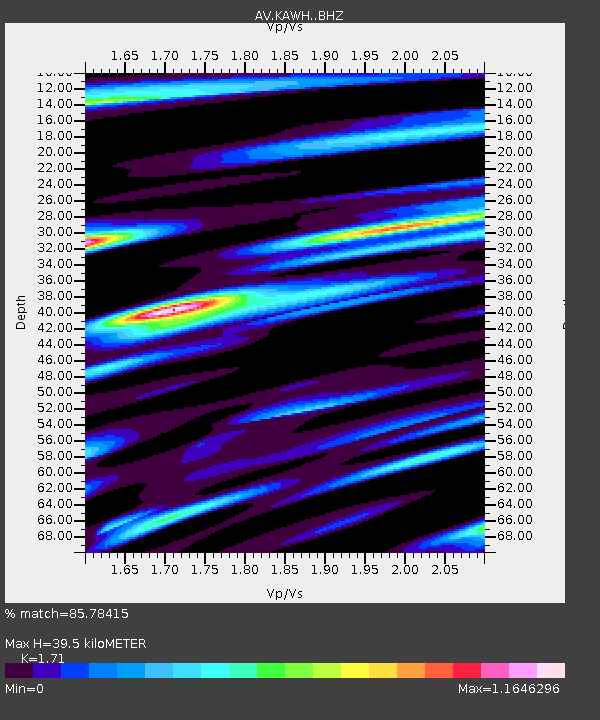
| Estimated Moho Depth: |
39.5 km |
| Estimated Crust Vp/Vs: |
1.71 |
| Assumed Crust Vp: |
6.438 km/s |
| Estimated Crust Vs: |
3.765 km/s |
| Estimated Crust Poisson's Ratio: |
0.24 |
|
| Radial Match: |
85.78415 % |
| Radial Bump: |
400 |
| Transverse Match: |
73.743454 % |
| Transverse Bump: |
400 |
| SOD ConfigId: |
33437571 |
| Insert Time: |
2024-02-05 18:17:08.208 +0000 |
| GWidth: |
2.5 |
| Max Bumps: |
400 |
| Tol: |
0.001 |
|

Signal To Noise
| Channel | StoN | STA | LTA |
| AV:KAWH: :BHZ:20240122T18:19:51.818989Z | 3.5313072 | 1.7918359E-6 | 5.074143E-7 |
| AV:KAWH: :BHN:20240122T18:19:51.818989Z | 2.9743598 | 9.639523E-7 | 3.240873E-7 |
| AV:KAWH: :BHE:20240122T18:19:51.818989Z | 2.589947 | 9.703732E-7 | 3.7466913E-7 |
| Arrivals |
| Ps | 4.5 SECOND |
| PpPs | 16 SECOND |
| PsPs/PpSs | 21 SECOND |


